You are here: Home > Network List > TA - USArray Transportable Network (new EarthScope stations) Stations List
> Station R32A Long Quarter, Great Bend, KS, USA > Earthquake Result Viewer
R32A Long Quarter, Great Bend, KS, USA - Earthquake Result Viewer
| Earthquake location: |
Near Coast Of Central Chile |
| Earthquake latitude/longitude: |
-37.0/-73.4 |
| Earthquake time(UTC): |
2010/09/09 (252) 07:28:01 GMT |
| Earthquake Depth: |
16 km |
| Earthquake Magnitude: |
5.8 MB, 6.0 MS, 6.2 MW, 6.2 MW |
| Earthquake Catalog/Contributor: |
WHDF/NEIC |
|
| Network: |
TA USArray Transportable Network (new EarthScope stations) |
| Station: |
R32A Long Quarter, Great Bend, KS, USA |
| Lat/Lon: |
38.42 N/98.71 W |
| Elevation: |
573 m |
|
| Distance: |
78.6 deg |
| Az: |
339.978 deg |
| Baz: |
159.585 deg |
| Ray Param: |
0.049498584 |
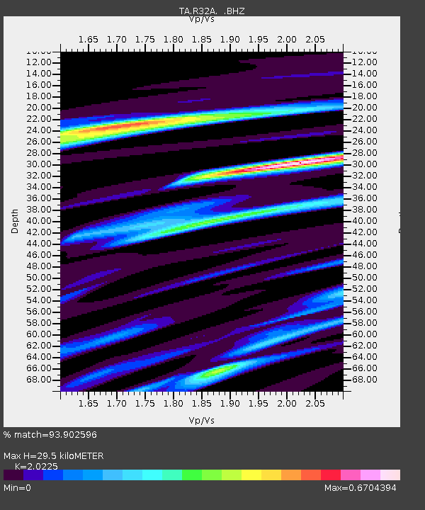
| Estimated Moho Depth: |
29.5 km |
| Estimated Crust Vp/Vs: |
2.02 |
| Assumed Crust Vp: |
6.483 km/s |
| Estimated Crust Vs: |
3.205 km/s |
| Estimated Crust Poisson's Ratio: |
0.34 |
|
| Radial Match: |
93.902596 % |
| Radial Bump: |
373 |
| Transverse Match: |
79.37918 % |
| Transverse Bump: |
400 |
| SOD ConfigId: |
319893 |
| Insert Time: |
2011-01-13 09:49:11.731 +0000 |
| GWidth: |
2.5 |
| Max Bumps: |
400 |
| Tol: |
0.001 |
|
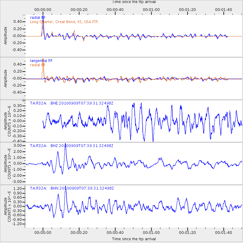
Signal To Noise
| Channel | StoN | STA | LTA |
| TA:R32A: :BHZ:20100909T07:39:31.32498Z | 3.0421858 | 2.3910206E-7 | 7.8595484E-8 |
| TA:R32A: :BHN:20100909T07:39:31.32498Z | 1.4641291 | 1.2468367E-7 | 8.515892E-8 |
| TA:R32A: :BHE:20100909T07:39:31.32498Z | 0.7127384 | 5.295266E-8 | 7.429467E-8 |
| Arrivals |
| Ps | 4.8 SECOND |
| PpPs | 13 SECOND |
| PsPs/PpSs | 18 SECOND |


