You are here: Home > Network List > TA - USArray Transportable Network (new EarthScope stations) Stations List
> Station 434A Burnet, TX, USA > Earthquake Result Viewer
434A Burnet, TX, USA - Earthquake Result Viewer
| Earthquake location: |
Near Coast Of Central Chile |
| Earthquake latitude/longitude: |
-37.0/-73.4 |
| Earthquake time(UTC): |
2010/09/09 (252) 07:28:01 GMT |
| Earthquake Depth: |
16 km |
| Earthquake Magnitude: |
5.8 MB, 6.0 MS, 6.2 MW, 6.2 MW |
| Earthquake Catalog/Contributor: |
WHDF/NEIC |
|
| Network: |
TA USArray Transportable Network (new EarthScope stations) |
| Station: |
434A Burnet, TX, USA |
| Lat/Lon: |
30.81 N/98.27 W |
| Elevation: |
462 m |
|
| Distance: |
71.4 deg |
| Az: |
337.568 deg |
| Baz: |
159.212 deg |
| Ray Param: |
0.05434317 |
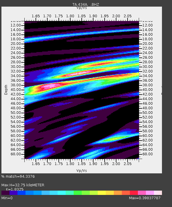
| Estimated Moho Depth: |
32.75 km |
| Estimated Crust Vp/Vs: |
1.83 |
| Assumed Crust Vp: |
6.498 km/s |
| Estimated Crust Vs: |
3.546 km/s |
| Estimated Crust Poisson's Ratio: |
0.29 |
|
| Radial Match: |
94.3376 % |
| Radial Bump: |
259 |
| Transverse Match: |
81.203674 % |
| Transverse Bump: |
400 |
| SOD ConfigId: |
319893 |
| Insert Time: |
2011-01-13 09:49:47.751 +0000 |
| GWidth: |
2.5 |
| Max Bumps: |
400 |
| Tol: |
0.001 |
|
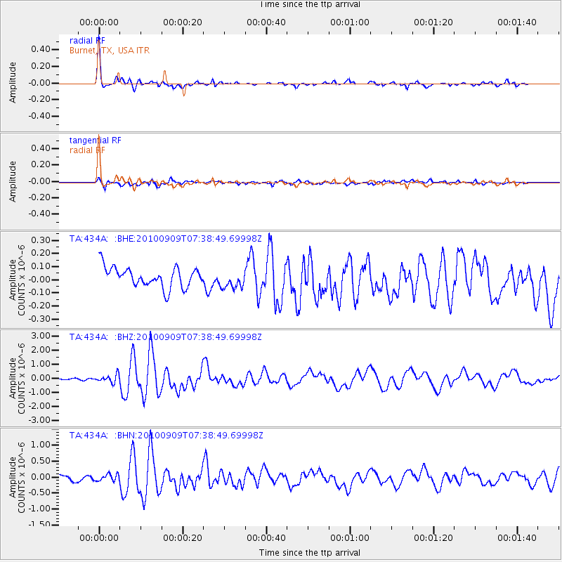
Signal To Noise
| Channel | StoN | STA | LTA |
| TA:434A: :BHZ:20100909T07:38:49.69998Z | 5.095544 | 2.8365264E-7 | 5.5666803E-8 |
| TA:434A: :BHN:20100909T07:38:49.69998Z | 1.5872145 | 1.1356799E-7 | 7.155176E-8 |
| TA:434A: :BHE:20100909T07:38:49.69998Z | 0.9248227 | 6.972966E-8 | 7.5397864E-8 |
| Arrivals |
| Ps | 4.3 SECOND |
| PpPs | 14 SECOND |
| PsPs/PpSs | 18 SECOND |


