You are here: Home > Network List > TA - USArray Transportable Network (new EarthScope stations) Stations List
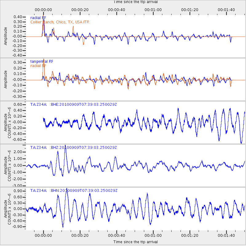
> Station Z34A Collier Ranch, Chico, TX, USA > Earthquake Result Viewer
Z34A Collier Ranch, Chico, TX, USA - Earthquake Result Viewer
| Earthquake location: |
Near Coast Of Central Chile |
| Earthquake latitude/longitude: |
-37.0/-73.4 |
| Earthquake time(UTC): |
2010/09/09 (252) 07:28:01 GMT |
| Earthquake Depth: |
16 km |
| Earthquake Magnitude: |
5.8 MB, 6.0 MS, 6.2 MW, 6.2 MW |
| Earthquake Catalog/Contributor: |
WHDF/NEIC |
|
| Network: |
TA USArray Transportable Network (new EarthScope stations) |
| Station: |
Z34A Collier Ranch, Chico, TX, USA |
| Lat/Lon: |
33.37 N/97.92 W |
| Elevation: |
341 m |
|
| Distance: |
73.7 deg |
| Az: |
338.799 deg |
| Baz: |
159.768 deg |
| Ray Param: |
0.05283085 |
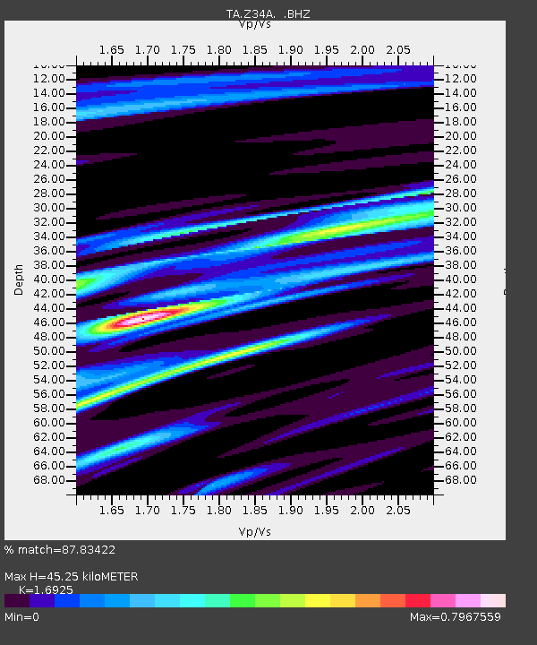
| Estimated Moho Depth: |
45.25 km |
| Estimated Crust Vp/Vs: |
1.69 |
| Assumed Crust Vp: |
6.38 km/s |
| Estimated Crust Vs: |
3.77 km/s |
| Estimated Crust Poisson's Ratio: |
0.23 |
|
| Radial Match: |
87.83422 % |
| Radial Bump: |
400 |
| Transverse Match: |
83.30925 % |
| Transverse Bump: |
319 |
| SOD ConfigId: |
319893 |
| Insert Time: |
2011-01-13 09:49:59.099 +0000 |
| GWidth: |
2.5 |
| Max Bumps: |
400 |
| Tol: |
0.001 |
|
Signal To Noise
| Channel | StoN | STA | LTA |
| TA:Z34A: :BHZ:20100909T07:39:03.250029Z | 2.7133164 | 2.5633074E-7 | 9.447138E-8 |
| TA:Z34A: :BHN:20100909T07:39:03.250029Z | 1.0676986 | 1.1945392E-7 | 1.11879814E-7 |
| TA:Z34A: :BHE:20100909T07:39:03.250029Z | 1.433952 | 1.5112491E-7 | 1.053905E-7 |
| Arrivals |
| Ps | 5.1 SECOND |
| PpPs | 18 SECOND |
| PsPs/PpSs | 24 SECOND |


