You are here: Home > Network List > TA - USArray Transportable Network (new EarthScope stations) Stations List
> Station 335A Moody, TX, USA > Earthquake Result Viewer
335A Moody, TX, USA - Earthquake Result Viewer
| Earthquake location: |
Near Coast Of Central Chile |
| Earthquake latitude/longitude: |
-37.0/-73.4 |
| Earthquake time(UTC): |
2010/09/09 (252) 07:28:01 GMT |
| Earthquake Depth: |
16 km |
| Earthquake Magnitude: |
5.8 MB, 6.0 MS, 6.2 MW, 6.2 MW |
| Earthquake Catalog/Contributor: |
WHDF/NEIC |
|
| Network: |
TA USArray Transportable Network (new EarthScope stations) |
| Station: |
335A Moody, TX, USA |
| Lat/Lon: |
31.28 N/97.43 W |
| Elevation: |
217 m |
|
| Distance: |
71.6 deg |
| Az: |
338.454 deg |
| Baz: |
159.925 deg |
| Ray Param: |
0.054219775 |
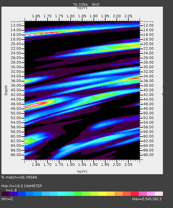
| Estimated Moho Depth: |
16.0 km |
| Estimated Crust Vp/Vs: |
1.60 |
| Assumed Crust Vp: |
6.347 km/s |
| Estimated Crust Vs: |
3.967 km/s |
| Estimated Crust Poisson's Ratio: |
0.18 |
|
| Radial Match: |
86.39596 % |
| Radial Bump: |
400 |
| Transverse Match: |
81.60029 % |
| Transverse Bump: |
400 |
| SOD ConfigId: |
319893 |
| Insert Time: |
2011-01-13 09:50:11.902 +0000 |
| GWidth: |
2.5 |
| Max Bumps: |
400 |
| Tol: |
0.001 |
|

Signal To Noise
| Channel | StoN | STA | LTA |
| TA:335A: :BHZ:20100909T07:38:50.800017Z | 2.0752342 | 2.1080892E-7 | 1.015832E-7 |
| TA:335A: :BHN:20100909T07:38:50.800017Z | 1.8497169 | 1.2542563E-7 | 6.780802E-8 |
| TA:335A: :BHE:20100909T07:38:50.800017Z | 1.0965773 | 5.1857494E-8 | 4.729032E-8 |
| Arrivals |
| Ps | 1.6 SECOND |
| PpPs | 6.3 SECOND |
| PsPs/PpSs | 7.9 SECOND |


