You are here: Home > Network List > TA - USArray Transportable Network (new EarthScope stations) Stations List
> Station 734A La Parita Creek, Jourdanton, TX, USA > Earthquake Result Viewer
734A La Parita Creek, Jourdanton, TX, USA - Earthquake Result Viewer
| Earthquake location: |
Near Coast Of Central Chile |
| Earthquake latitude/longitude: |
-37.0/-73.4 |
| Earthquake time(UTC): |
2010/09/09 (252) 07:28:01 GMT |
| Earthquake Depth: |
16 km |
| Earthquake Magnitude: |
5.8 MB, 6.0 MS, 6.2 MW, 6.2 MW |
| Earthquake Catalog/Contributor: |
WHDF/NEIC |
|
| Network: |
TA USArray Transportable Network (new EarthScope stations) |
| Station: |
734A La Parita Creek, Jourdanton, TX, USA |
| Lat/Lon: |
28.85 N/98.56 W |
| Elevation: |
121 m |
|
| Distance: |
69.7 deg |
| Az: |
336.574 deg |
| Baz: |
158.737 deg |
| Ray Param: |
0.05548887 |
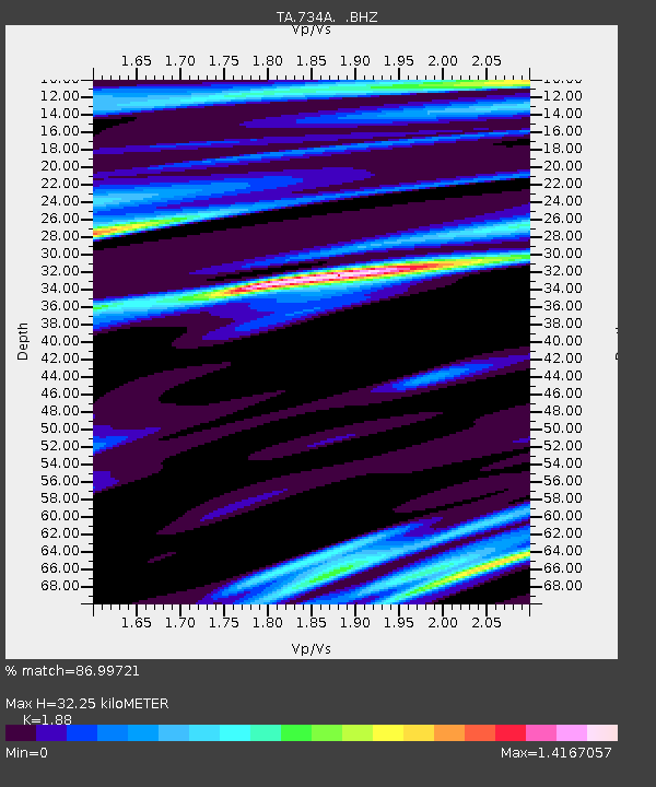
| Estimated Moho Depth: |
32.25 km |
| Estimated Crust Vp/Vs: |
1.88 |
| Assumed Crust Vp: |
6.347 km/s |
| Estimated Crust Vs: |
3.376 km/s |
| Estimated Crust Poisson's Ratio: |
0.30 |
|
| Radial Match: |
86.99721 % |
| Radial Bump: |
400 |
| Transverse Match: |
62.262424 % |
| Transverse Bump: |
400 |
| SOD ConfigId: |
319893 |
| Insert Time: |
2011-01-13 09:50:33.105 +0000 |
| GWidth: |
2.5 |
| Max Bumps: |
400 |
| Tol: |
0.001 |
|

Signal To Noise
| Channel | StoN | STA | LTA |
| TA:734A: :BHZ:20100909T07:38:39.100005Z | 1.9352783 | 3.5660125E-7 | 1.8426354E-7 |
| TA:734A: :BHN:20100909T07:38:39.100005Z | 0.49441192 | 1.3253447E-7 | 2.6806487E-7 |
| TA:734A: :BHE:20100909T07:38:39.100005Z | 0.71648455 | 2.0413236E-7 | 2.8490825E-7 |
| Arrivals |
| Ps | 4.6 SECOND |
| PpPs | 14 SECOND |
| PsPs/PpSs | 19 SECOND |


