You are here: Home > Network List > TA - USArray Transportable Network (new EarthScope stations) Stations List
> Station 833A Chaparral WMA, Artesia Wells, TX, USA > Earthquake Result Viewer
833A Chaparral WMA, Artesia Wells, TX, USA - Earthquake Result Viewer

| Earthquake location: |
Near Coast Of Central Chile |
| Earthquake latitude/longitude: |
-37.0/-73.4 |
| Earthquake time(UTC): |
2010/09/09 (252) 07:28:01 GMT |
| Earthquake Depth: |
16 km |
| Earthquake Magnitude: |
5.8 MB, 6.0 MS, 6.2 MW, 6.2 MW |
| Earthquake Catalog/Contributor: |
WHDF/NEIC |
|
| Network: |
TA USArray Transportable Network (new EarthScope stations) |
| Station: |
833A Chaparral WMA, Artesia Wells, TX, USA |
| Lat/Lon: |
28.32 N/99.39 W |
| Elevation: |
171 m |
|
| Distance: |
69.4 deg |
| Az: |
335.639 deg |
| Baz: |
158.013 deg |
| Ray Param: |
0.055631287 |
| Estimated Moho Depth: |
10.0 km |
| Estimated Crust Vp/Vs: |
1.87 |
| Assumed Crust Vp: |
6.347 km/s |
| Estimated Crust Vs: |
3.403 km/s |
| Estimated Crust Poisson's Ratio: |
0.30 |
|
| Radial Match: |
87.891426 % |
| Radial Bump: |
389 |
| Transverse Match: |
87.36229 % |
| Transverse Bump: |
400 |
| SOD ConfigId: |
319893 |
| Insert Time: |
2011-01-13 09:50:45.350 +0000 |
| GWidth: |
2.5 |
| Max Bumps: |
400 |
| Tol: |
0.001 |
|
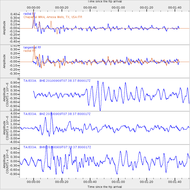
Signal To Noise
| Channel | StoN | STA | LTA |
| TA:833A: :BHZ:20100909T07:38:37.800017Z | 4.2271543 | 4.0537415E-7 | 9.5897654E-8 |
| TA:833A: :BHN:20100909T07:38:37.800017Z | 1.589047 | 1.6964839E-7 | 1.06761085E-7 |
| TA:833A: :BHE:20100909T07:38:37.800017Z | 0.80739516 | 8.3631036E-8 | 1.0358129E-7 |
| Arrivals |
| Ps | 1.4 SECOND |
| PpPs | 4.4 SECOND |
| PsPs/PpSs | 5.8 SECOND |


