You are here: Home > Network List > TA - USArray Transportable Network (new EarthScope stations) Stations List
> Station 634A China Grove, San Antonio TX, USA > Earthquake Result Viewer
634A China Grove, San Antonio TX, USA - Earthquake Result Viewer
| Earthquake location: |
Near Coast Of Central Chile |
| Earthquake latitude/longitude: |
-37.0/-73.4 |
| Earthquake time(UTC): |
2010/09/09 (252) 07:28:01 GMT |
| Earthquake Depth: |
16 km |
| Earthquake Magnitude: |
5.8 MB, 6.0 MS, 6.2 MW, 6.2 MW |
| Earthquake Catalog/Contributor: |
WHDF/NEIC |
|
| Network: |
TA USArray Transportable Network (new EarthScope stations) |
| Station: |
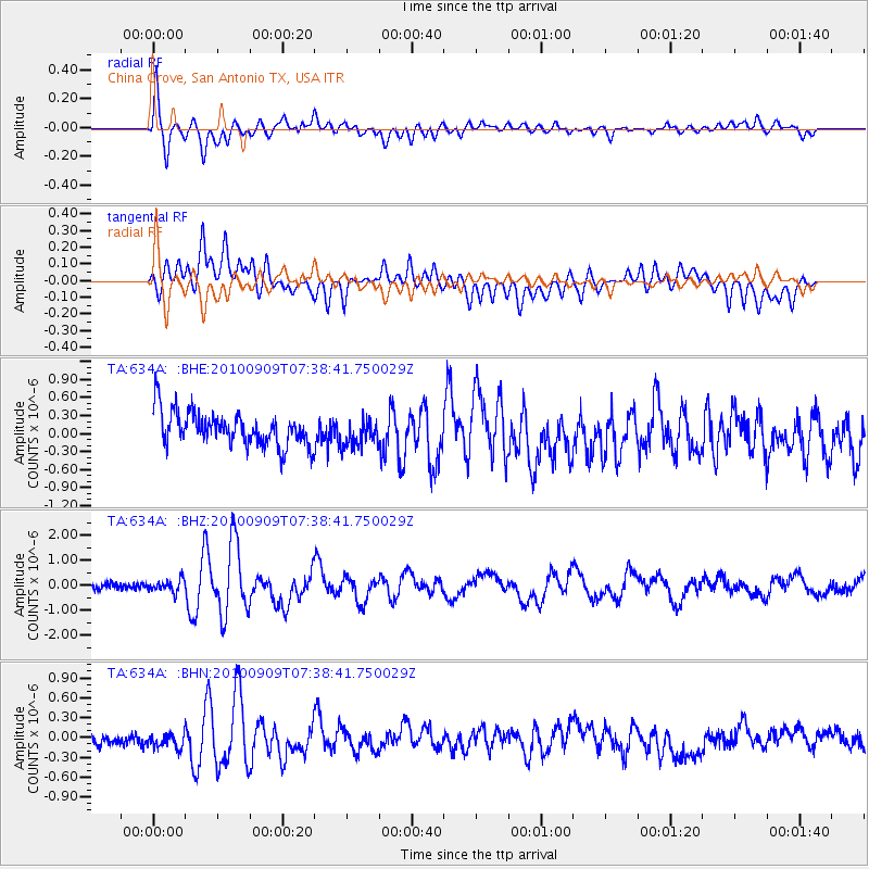
634A China Grove, San Antonio TX, USA |
| Lat/Lon: |
29.38 N/98.35 W |
| Elevation: |
188 m |
|
| Distance: |
70.1 deg |
| Az: |
336.958 deg |
| Baz: |
158.969 deg |
| Ray Param: |
0.05520201 |
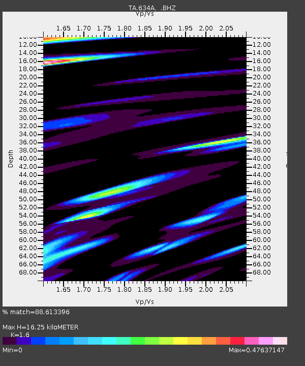
| Estimated Moho Depth: |
16.25 km |
| Estimated Crust Vp/Vs: |
1.60 |
| Assumed Crust Vp: |
6.347 km/s |
| Estimated Crust Vs: |
3.967 km/s |
| Estimated Crust Poisson's Ratio: |
0.18 |
|
| Radial Match: |
88.613396 % |
| Radial Bump: |
400 |
| Transverse Match: |
70.22172 % |
| Transverse Bump: |
400 |
| SOD ConfigId: |
319893 |
| Insert Time: |
2011-01-13 09:50:49.136 +0000 |
| GWidth: |
2.5 |
| Max Bumps: |
400 |
| Tol: |
0.001 |
|
Signal To Noise
| Channel | StoN | STA | LTA |
| TA:634A: :BHZ:20100909T07:38:41.750029Z | 2.2572267 | 2.465583E-7 | 1.09230626E-7 |
| TA:634A: :BHN:20100909T07:38:41.750029Z | 1.5270537 | 1.2916439E-7 | 8.458405E-8 |
| TA:634A: :BHE:20100909T07:38:41.750029Z | 0.8186327 | 2.272346E-7 | 2.775782E-7 |
| Arrivals |
| Ps | 1.6 SECOND |
| PpPs | 6.4 SECOND |
| PsPs/PpSs | 8.0 SECOND |


