You are here: Home > Network List > CN - Canadian National Seismograph Network Stations List
> Station PNPO PUKASKWA, ON > Earthquake Result Viewer
PNPO PUKASKWA, ON - Earthquake Result Viewer
| Earthquake location: |
Western Brazil |
| Earthquake latitude/longitude: |
-8.2/-71.4 |
| Earthquake time(UTC): |
2024/01/28 (028) 09:38:56 GMT |
| Earthquake Depth: |
609 km |
| Earthquake Magnitude: |
6.5 Mww |
| Earthquake Catalog/Contributor: |
NEIC PDE/us |
|
| Network: |
CN Canadian National Seismograph Network |
| Station: |
PNPO PUKASKWA, ON |
| Lat/Lon: |
48.60 N/86.28 W |
| Elevation: |
219 m |
|
| Distance: |
58.1 deg |
| Az: |
348.384 deg |
| Baz: |
162.528 deg |
| Ray Param: |
0.060538515 |
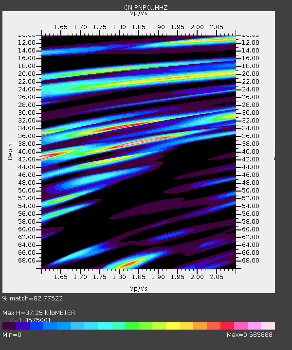
| Estimated Moho Depth: |
37.25 km |
| Estimated Crust Vp/Vs: |
1.86 |
| Assumed Crust Vp: |
6.472 km/s |
| Estimated Crust Vs: |
3.484 km/s |
| Estimated Crust Poisson's Ratio: |
0.30 |
|
| Radial Match: |
82.77522 % |
| Radial Bump: |
314 |
| Transverse Match: |
70.440094 % |
| Transverse Bump: |
361 |
| SOD ConfigId: |
33437571 |
| Insert Time: |
2024-02-11 09:53:32.510 +0000 |
| GWidth: |
2.5 |
| Max Bumps: |
400 |
| Tol: |
0.001 |
|

Signal To Noise
| Channel | StoN | STA | LTA |
| CN:PNPO: :HHZ:20240128T09:47:22.049999Z | 29.906435 | 3.5447074E-6 | 1.1852658E-7 |
| CN:PNPO: :HHN:20240128T09:47:22.049999Z | 6.973348 | 1.3729318E-6 | 1.9688274E-7 |
| CN:PNPO: :HHE:20240128T09:47:22.049999Z | 5.0762453 | 7.2665136E-7 | 1.431474E-7 |
| Arrivals |
| Ps | 5.2 SECOND |
| PpPs | 16 SECOND |
| PsPs/PpSs | 21 SECOND |


