You are here: Home > Network List > TA - USArray Transportable Network (new EarthScope stations) Stations List
> Station Q34A Chapman, KS, USA > Earthquake Result Viewer
Q34A Chapman, KS, USA - Earthquake Result Viewer
| Earthquake location: |
Near Coast Of Central Chile |
| Earthquake latitude/longitude: |
-37.0/-73.4 |
| Earthquake time(UTC): |
2010/09/09 (252) 07:28:01 GMT |
| Earthquake Depth: |
16 km |
| Earthquake Magnitude: |
5.8 MB, 6.0 MS, 6.2 MW, 6.2 MW |
| Earthquake Catalog/Contributor: |
WHDF/NEIC |
|
| Network: |
TA USArray Transportable Network (new EarthScope stations) |
| Station: |
Q34A Chapman, KS, USA |
| Lat/Lon: |
38.92 N/96.94 W |
| Elevation: |
378 m |
|
| Distance: |
78.6 deg |
| Az: |
341.48 deg |
| Baz: |
160.983 deg |
| Ray Param: |
0.04949762 |
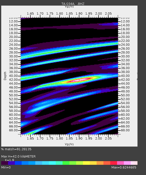
| Estimated Moho Depth: |
42.0 km |
| Estimated Crust Vp/Vs: |
1.90 |
| Assumed Crust Vp: |
6.483 km/s |
| Estimated Crust Vs: |
3.412 km/s |
| Estimated Crust Poisson's Ratio: |
0.31 |
|
| Radial Match: |
91.28135 % |
| Radial Bump: |
393 |
| Transverse Match: |
73.91812 % |
| Transverse Bump: |
400 |
| SOD ConfigId: |
319893 |
| Insert Time: |
2011-01-13 09:53:35.692 +0000 |
| GWidth: |
2.5 |
| Max Bumps: |
400 |
| Tol: |
0.001 |
|
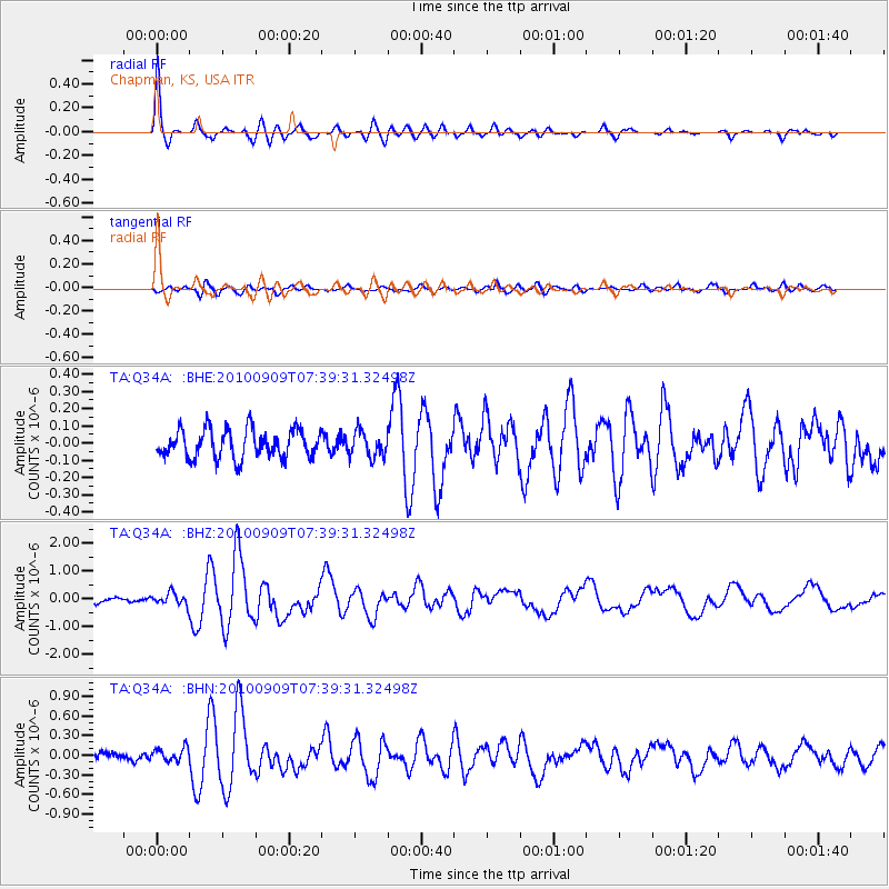
Signal To Noise
| Channel | StoN | STA | LTA |
| TA:Q34A: :BHZ:20100909T07:39:31.32498Z | 2.3545012 | 2.2049463E-7 | 9.364812E-8 |
| TA:Q34A: :BHN:20100909T07:39:31.32498Z | 1.201575 | 1.0432025E-7 | 8.681959E-8 |
| TA:Q34A: :BHE:20100909T07:39:31.32498Z | 0.8989066 | 7.336983E-8 | 8.16212E-8 |
| Arrivals |
| Ps | 6.0 SECOND |
| PpPs | 18 SECOND |
| PsPs/PpSs | 24 SECOND |


