You are here: Home > Network List > TA - USArray Transportable Network (new EarthScope stations) Stations List
> Station N34A Lincoln, NE, USA > Earthquake Result Viewer
N34A Lincoln, NE, USA - Earthquake Result Viewer
| Earthquake location: |
Near Coast Of Central Chile |
| Earthquake latitude/longitude: |
-37.0/-73.4 |
| Earthquake time(UTC): |
2010/09/09 (252) 07:28:01 GMT |
| Earthquake Depth: |
16 km |
| Earthquake Magnitude: |
5.8 MB, 6.0 MS, 6.2 MW, 6.2 MW |
| Earthquake Catalog/Contributor: |
WHDF/NEIC |
|
| Network: |
TA USArray Transportable Network (new EarthScope stations) |
| Station: |
N34A Lincoln, NE, USA |
| Lat/Lon: |
40.84 N/96.50 W |
| Elevation: |
401 m |
|
| Distance: |
80.3 deg |
| Az: |
342.433 deg |
| Baz: |
161.438 deg |
| Ray Param: |
0.048335087 |
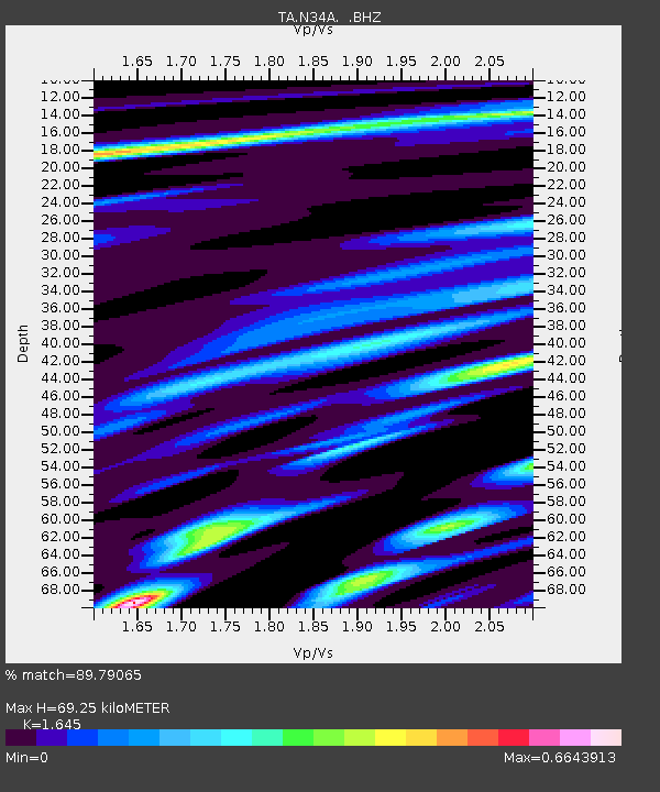
| Estimated Moho Depth: |
69.25 km |
| Estimated Crust Vp/Vs: |
1.64 |
| Assumed Crust Vp: |
6.498 km/s |
| Estimated Crust Vs: |
3.95 km/s |
| Estimated Crust Poisson's Ratio: |
0.21 |
|
| Radial Match: |
89.79065 % |
| Radial Bump: |
400 |
| Transverse Match: |
63.907238 % |
| Transverse Bump: |
400 |
| SOD ConfigId: |
319893 |
| Insert Time: |
2011-01-13 09:53:50.976 +0000 |
| GWidth: |
2.5 |
| Max Bumps: |
400 |
| Tol: |
0.001 |
|
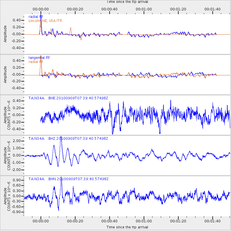
Signal To Noise
| Channel | StoN | STA | LTA |
| TA:N34A: :BHZ:20100909T07:39:40.57498Z | 3.4848552 | 2.3116081E-7 | 6.633297E-8 |
| TA:N34A: :BHN:20100909T07:39:40.57498Z | 1.4886104 | 1.3588858E-7 | 9.128553E-8 |
| TA:N34A: :BHE:20100909T07:39:40.57498Z | 1.1063327 | 1.2619985E-7 | 1.1407043E-7 |
| Arrivals |
| Ps | 7.1 SECOND |
| PpPs | 27 SECOND |
| PsPs/PpSs | 34 SECOND |


