You are here: Home > Network List > GM - US Geological Survey Networks Stations List
> Station NMP12 New Mexico Permian - Site# W1S2 > Earthquake Result Viewer
NMP12 New Mexico Permian - Site# W1S2 - Earthquake Result Viewer
| Earthquake location: |
Western Brazil |
| Earthquake latitude/longitude: |
-8.2/-71.4 |
| Earthquake time(UTC): |
2024/01/28 (028) 09:38:56 GMT |
| Earthquake Depth: |
609 km |
| Earthquake Magnitude: |
6.5 Mww |
| Earthquake Catalog/Contributor: |
NEIC PDE/us |
|
| Network: |
GM US Geological Survey Networks |
| Station: |
NMP12 New Mexico Permian - Site# W1S2 |
| Lat/Lon: |
32.13 N/103.95 W |
| Elevation: |
952 m |
|
| Distance: |
50.8 deg |
| Az: |
323.845 deg |
| Baz: |
136.505 deg |
| Ray Param: |
0.06500812 |
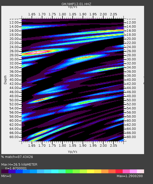
| Estimated Moho Depth: |
26.5 km |
| Estimated Crust Vp/Vs: |
1.67 |
| Assumed Crust Vp: |
6.129 km/s |
| Estimated Crust Vs: |
3.67 km/s |
| Estimated Crust Poisson's Ratio: |
0.22 |
|
| Radial Match: |
87.43426 % |
| Radial Bump: |
400 |
| Transverse Match: |
84.06063 % |
| Transverse Bump: |
400 |
| SOD ConfigId: |
33437571 |
| Insert Time: |
2024-02-11 09:56:07.586 +0000 |
| GWidth: |
2.5 |
| Max Bumps: |
400 |
| Tol: |
0.001 |
|

Signal To Noise
| Channel | StoN | STA | LTA |
| GM:NMP12:01:HHZ:20240128T09:46:31.169994Z | 6.415514 | 1.7625119E-6 | 2.7472652E-7 |
| GM:NMP12:01:HHN:20240128T09:46:31.169994Z | 2.3481033 | 4.3991346E-7 | 1.8734843E-7 |
| GM:NMP12:01:HHE:20240128T09:46:31.169994Z | 4.647426 | 8.3389165E-7 | 1.7943084E-7 |
| Arrivals |
| Ps | 3.0 SECOND |
| PpPs | 11 SECOND |
| PsPs/PpSs | 14 SECOND |


