You are here: Home > Network List > TA - USArray Transportable Network (new EarthScope stations) Stations List
> Station O36A Bolckow, MO, USA > Earthquake Result Viewer
O36A Bolckow, MO, USA - Earthquake Result Viewer
| Earthquake location: |
Near Coast Of Central Chile |
| Earthquake latitude/longitude: |
-37.0/-73.4 |
| Earthquake time(UTC): |
2010/09/09 (252) 07:28:01 GMT |
| Earthquake Depth: |
16 km |
| Earthquake Magnitude: |
5.8 MB, 6.0 MS, 6.2 MW, 6.2 MW |
| Earthquake Catalog/Contributor: |
WHDF/NEIC |
|
| Network: |
TA USArray Transportable Network (new EarthScope stations) |
| Station: |
O36A Bolckow, MO, USA |
| Lat/Lon: |
40.13 N/94.96 W |
| Elevation: |
306 m |
|
| Distance: |
79.3 deg |
| Az: |
343.344 deg |
| Baz: |
162.593 deg |
| Ray Param: |
0.049041957 |
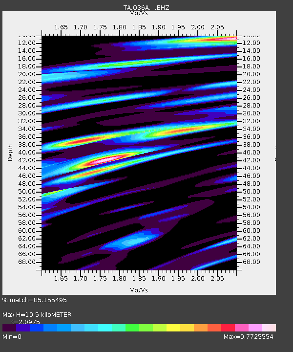
| Estimated Moho Depth: |
10.5 km |
| Estimated Crust Vp/Vs: |
2.10 |
| Assumed Crust Vp: |
6.498 km/s |
| Estimated Crust Vs: |
3.098 km/s |
| Estimated Crust Poisson's Ratio: |
0.35 |
|
| Radial Match: |
85.155495 % |
| Radial Bump: |
400 |
| Transverse Match: |
74.53021 % |
| Transverse Bump: |
400 |
| SOD ConfigId: |
319893 |
| Insert Time: |
2011-01-13 09:54:24.396 +0000 |
| GWidth: |
2.5 |
| Max Bumps: |
400 |
| Tol: |
0.001 |
|
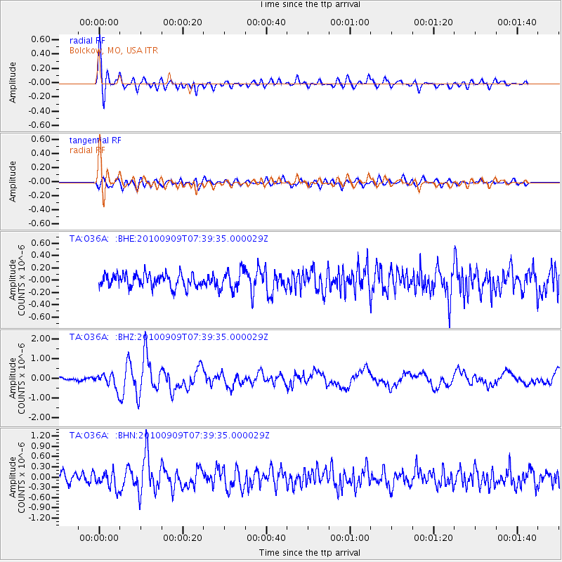
Signal To Noise
| Channel | StoN | STA | LTA |
| TA:O36A: :BHZ:20100909T07:39:35.000029Z | 7.2395267 | 3.8171368E-7 | 5.2726328E-8 |
| TA:O36A: :BHN:20100909T07:39:35.000029Z | 1.6693975 | 2.4972607E-7 | 1.4959055E-7 |
| TA:O36A: :BHE:20100909T07:39:35.000029Z | 1.5216367 | 1.5831012E-7 | 1.0403936E-7 |
| Arrivals |
| Ps | 1.8 SECOND |
| PpPs | 4.9 SECOND |
| PsPs/PpSs | 6.7 SECOND |


