You are here: Home > Network List > GS - US Geological Survey Networks Stations List
> Station OK051 E0350 and S34600 roads, Ralston OK > Earthquake Result Viewer
OK051 E0350 and S34600 roads, Ralston OK - Earthquake Result Viewer

| Earthquake location: |
Western Brazil |
| Earthquake latitude/longitude: |
-8.2/-71.4 |
| Earthquake time(UTC): |
2024/01/28 (028) 09:38:56 GMT |
| Earthquake Depth: |
609 km |
| Earthquake Magnitude: |
6.5 Mww |
| Earthquake Catalog/Contributor: |
NEIC PDE/us |
|
| Network: |
GS US Geological Survey Networks |
| Station: |
OK051 E0350 and S34600 roads, Ralston OK |
| Lat/Lon: |
36.50 N/96.84 W |
| Elevation: |
263 m |
|
| Distance: |
50.5 deg |
| Az: |
333.323 deg |
| Baz: |
146.525 deg |
| Ray Param: |
0.06516705 |
| Estimated Moho Depth: |
42.5 km |
| Estimated Crust Vp/Vs: |
1.78 |
| Assumed Crust Vp: |
6.483 km/s |
| Estimated Crust Vs: |
3.642 km/s |
| Estimated Crust Poisson's Ratio: |
0.27 |
|
| Radial Match: |
91.12853 % |
| Radial Bump: |
300 |
| Transverse Match: |
68.11077 % |
| Transverse Bump: |
400 |
| SOD ConfigId: |
33437571 |
| Insert Time: |
2024-02-11 09:56:47.609 +0000 |
| GWidth: |
2.5 |
| Max Bumps: |
400 |
| Tol: |
0.001 |
|
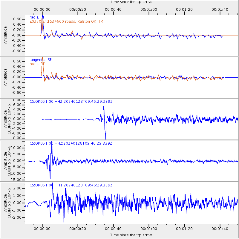
Signal To Noise
| Channel | StoN | STA | LTA |
| GS:OK051:00:HHZ:20240128T09:46:29.339Z | 30.10788 | 3.7795583E-6 | 1.2553386E-7 |
| GS:OK051:00:HH1:20240128T09:46:29.339Z | 2.722725 | 5.274623E-7 | 1.9372588E-7 |
| GS:OK051:00:HH2:20240128T09:46:29.339Z | 14.005594 | 1.5943466E-6 | 1.1383641E-7 |
| Arrivals |
| Ps | 5.4 SECOND |
| PpPs | 17 SECOND |
| PsPs/PpSs | 23 SECOND |


