You are here: Home > Network List > GS - US Geological Survey Networks Stations List
> Station OK052 Battle Ridge Rd, NW of Cushing, Oklahoma USA > Earthquake Result Viewer
OK052 Battle Ridge Rd, NW of Cushing, Oklahoma USA - Earthquake Result Viewer
| Earthquake location: |
Western Brazil |
| Earthquake latitude/longitude: |
-8.2/-71.4 |
| Earthquake time(UTC): |
2024/01/28 (028) 09:38:56 GMT |
| Earthquake Depth: |
609 km |
| Earthquake Magnitude: |
6.5 Mww |
| Earthquake Catalog/Contributor: |
NEIC PDE/us |
|
| Network: |
GS US Geological Survey Networks |
| Station: |
OK052 Battle Ridge Rd, NW of Cushing, Oklahoma USA |
| Lat/Lon: |
36.00 N/96.80 W |
| Elevation: |
261 m |
|
| Distance: |
50.1 deg |
| Az: |
332.987 deg |
| Baz: |
146.33 deg |
| Ray Param: |
0.06543466 |
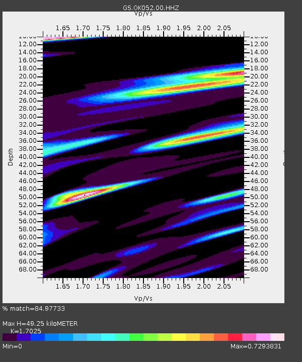
| Estimated Moho Depth: |
49.25 km |
| Estimated Crust Vp/Vs: |
1.70 |
| Assumed Crust Vp: |
6.426 km/s |
| Estimated Crust Vs: |
3.775 km/s |
| Estimated Crust Poisson's Ratio: |
0.24 |
|
| Radial Match: |
84.97733 % |
| Radial Bump: |
330 |
| Transverse Match: |
70.72064 % |
| Transverse Bump: |
373 |
| SOD ConfigId: |
33437571 |
| Insert Time: |
2024-02-11 09:56:48.851 +0000 |
| GWidth: |
2.5 |
| Max Bumps: |
400 |
| Tol: |
0.001 |
|

Signal To Noise
| Channel | StoN | STA | LTA |
| GS:OK052:00:HHZ:20240128T09:46:26.160015Z | 34.863422 | 5.522878E-6 | 1.5841468E-7 |
| GS:OK052:00:HH1:20240128T09:46:26.160015Z | 7.623947 | 1.4918185E-6 | 1.9567534E-7 |
| GS:OK052:00:HH2:20240128T09:46:26.160015Z | 10.479902 | 1.3511539E-6 | 1.2892811E-7 |
| Arrivals |
| Ps | 5.7 SECOND |
| PpPs | 20 SECOND |
| PsPs/PpSs | 25 SECOND |


