You are here: Home > Network List > TA - USArray Transportable Network (new EarthScope stations) Stations List
> Station L33A Hoskins, NE, USA > Earthquake Result Viewer
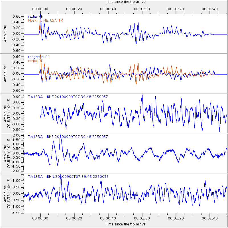
L33A Hoskins, NE, USA - Earthquake Result Viewer
*The percent match for this event was below the threshold and hence no stack was calculated.
| Earthquake location: |
Near Coast Of Central Chile |
| Earthquake latitude/longitude: |
-37.0/-73.4 |
| Earthquake time(UTC): |
2010/09/09 (252) 07:28:01 GMT |
| Earthquake Depth: |
16 km |
| Earthquake Magnitude: |
5.8 MB, 6.0 MS, 6.2 MW, 6.2 MW |
| Earthquake Catalog/Contributor: |
WHDF/NEIC |
|
| Network: |
TA USArray Transportable Network (new EarthScope stations) |
| Station: |
L33A Hoskins, NE, USA |
| Lat/Lon: |
42.17 N/97.27 W |
| Elevation: |
556 m |
|
| Distance: |
81.8 deg |
| Az: |
342.311 deg |
| Baz: |
160.91 deg |
| Ray Param: |
$rayparam |
*The percent match for this event was below the threshold and hence was not used in the summary stack. |
|
| Radial Match: |
71.850716 % |
| Radial Bump: |
400 |
| Transverse Match: |
61.409443 % |
| Transverse Bump: |
400 |
| SOD ConfigId: |
319893 |
| Insert Time: |
2011-01-13 09:56:19.945 +0000 |
| GWidth: |
2.5 |
| Max Bumps: |
400 |
| Tol: |
0.001 |
|
Signal To Noise
| Channel | StoN | STA | LTA |
| TA:L33A: :BHZ:20100909T07:39:48.225005Z | 4.1672387 | 2.5945764E-7 | 6.2261286E-8 |
| TA:L33A: :BHN:20100909T07:39:48.225005Z | 0.8548012 | 1.9247578E-7 | 2.2517023E-7 |
| TA:L33A: :BHE:20100909T07:39:48.225005Z | 0.6083152 | 1.6802592E-7 | 2.7621522E-7 |
| Arrivals |
| Ps | |
| PpPs | |
| PsPs/PpSs | |


