You are here: Home > Network List > TA - USArray Transportable Network (new EarthScope stations) Stations List
> Station U35A Pawnee, OK, USA > Earthquake Result Viewer
U35A Pawnee, OK, USA - Earthquake Result Viewer
| Earthquake location: |
Near Coast Of Central Chile |
| Earthquake latitude/longitude: |
-37.0/-73.4 |
| Earthquake time(UTC): |
2010/09/09 (252) 07:28:01 GMT |
| Earthquake Depth: |
16 km |
| Earthquake Magnitude: |
5.8 MB, 6.0 MS, 6.2 MW, 6.2 MW |
| Earthquake Catalog/Contributor: |
WHDF/NEIC |
|
| Network: |
TA USArray Transportable Network (new EarthScope stations) |
| Station: |
U35A Pawnee, OK, USA |
| Lat/Lon: |
36.37 N/96.73 W |
| Elevation: |
303 m |
|
| Distance: |
76.2 deg |
| Az: |
340.79 deg |
| Baz: |
160.96 deg |
| Ray Param: |
0.05116146 |
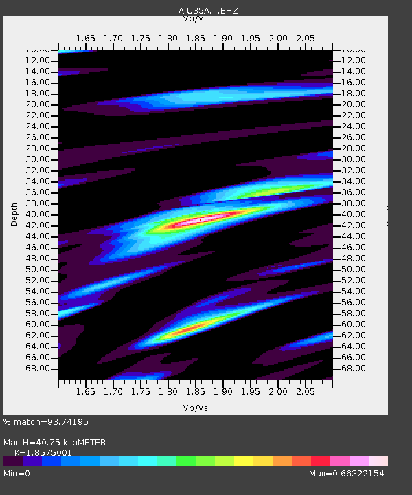
| Estimated Moho Depth: |
40.75 km |
| Estimated Crust Vp/Vs: |
1.86 |
| Assumed Crust Vp: |
6.483 km/s |
| Estimated Crust Vs: |
3.49 km/s |
| Estimated Crust Poisson's Ratio: |
0.30 |
|
| Radial Match: |
93.74195 % |
| Radial Bump: |
293 |
| Transverse Match: |
70.66093 % |
| Transverse Bump: |
400 |
| SOD ConfigId: |
319893 |
| Insert Time: |
2011-01-13 09:56:22.304 +0000 |
| GWidth: |
2.5 |
| Max Bumps: |
400 |
| Tol: |
0.001 |
|
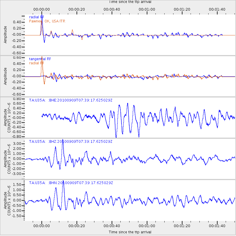
Signal To Noise
| Channel | StoN | STA | LTA |
| TA:U35A: :BHZ:20100909T07:39:17.625029Z | 2.690535 | 2.858634E-7 | 1.0624778E-7 |
| TA:U35A: :BHN:20100909T07:39:17.625029Z | 1.4720871 | 1.4453474E-7 | 9.818355E-8 |
| TA:U35A: :BHE:20100909T07:39:17.625029Z | 1.1586003 | 1.18052384E-7 | 1.0189224E-7 |
| Arrivals |
| Ps | 5.6 SECOND |
| PpPs | 17 SECOND |
| PsPs/PpSs | 23 SECOND |


