You are here: Home > Network List > N4 - Central and EAstern US Network Stations List
> Station SUSD Miller, SD, USA > Earthquake Result Viewer
SUSD Miller, SD, USA - Earthquake Result Viewer
| Earthquake location: |
Western Brazil |
| Earthquake latitude/longitude: |
-8.2/-71.4 |
| Earthquake time(UTC): |
2024/01/28 (028) 09:38:56 GMT |
| Earthquake Depth: |
609 km |
| Earthquake Magnitude: |
6.5 Mww |
| Earthquake Catalog/Contributor: |
NEIC PDE/us |
|
| Network: |
N4 Central and EAstern US Network |
| Station: |
SUSD Miller, SD, USA |
| Lat/Lon: |
44.44 N/98.96 W |
| Elevation: |
520 m |
|
| Distance: |
58.0 deg |
| Az: |
336.983 deg |
| Baz: |
147.293 deg |
| Ray Param: |
0.060560826 |
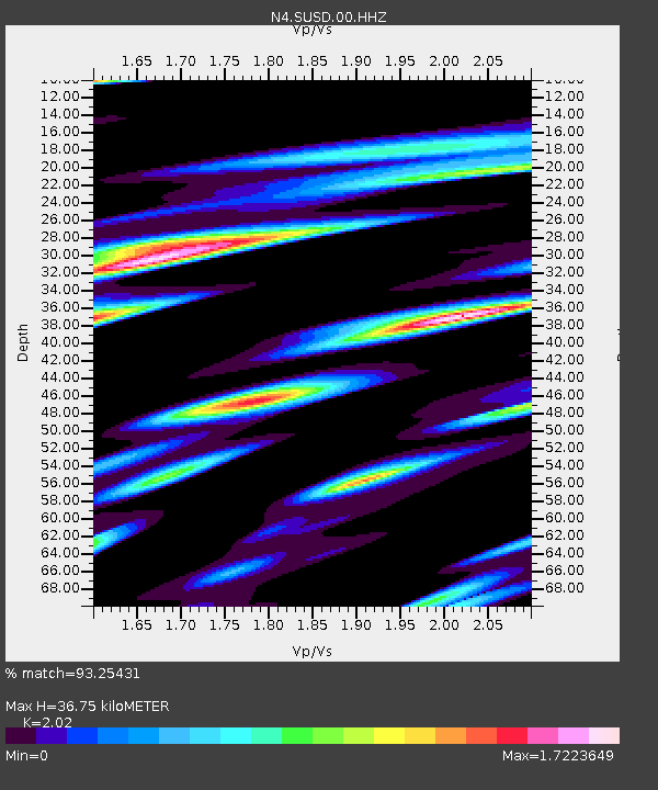
| Estimated Moho Depth: |
36.75 km |
| Estimated Crust Vp/Vs: |
2.02 |
| Assumed Crust Vp: |
6.53 km/s |
| Estimated Crust Vs: |
3.233 km/s |
| Estimated Crust Poisson's Ratio: |
0.34 |
|
| Radial Match: |
93.25431 % |
| Radial Bump: |
391 |
| Transverse Match: |
76.10521 % |
| Transverse Bump: |
400 |
| SOD ConfigId: |
33437571 |
| Insert Time: |
2024-02-11 10:01:51.997 +0000 |
| GWidth: |
2.5 |
| Max Bumps: |
400 |
| Tol: |
0.001 |
|

Signal To Noise
| Channel | StoN | STA | LTA |
| N4:SUSD:00:HHZ:20240128T09:47:21.809001Z | 19.075388 | 4.458985E-6 | 2.3375594E-7 |
| N4:SUSD:00:HH1:20240128T09:47:21.809001Z | 7.5574274 | 1.9020429E-6 | 2.516786E-7 |
| N4:SUSD:00:HH2:20240128T09:47:21.809001Z | 3.4934158 | 8.9921286E-7 | 2.5740218E-7 |
| Arrivals |
| Ps | 6.0 SECOND |
| PpPs | 16 SECOND |
| PsPs/PpSs | 22 SECOND |


