You are here: Home > Network List > TA - USArray Transportable Network (new EarthScope stations) Stations List
> Station K32A Verdigre, NE, USA > Earthquake Result Viewer
K32A Verdigre, NE, USA - Earthquake Result Viewer
| Earthquake location: |
Near Coast Of Central Chile |
| Earthquake latitude/longitude: |
-37.0/-73.4 |
| Earthquake time(UTC): |
2010/09/09 (252) 07:28:01 GMT |
| Earthquake Depth: |
16 km |
| Earthquake Magnitude: |
5.8 MB, 6.0 MS, 6.2 MW, 6.2 MW |
| Earthquake Catalog/Contributor: |
WHDF/NEIC |
|
| Network: |
TA USArray Transportable Network (new EarthScope stations) |
| Station: |
K32A Verdigre, NE, USA |
| Lat/Lon: |
42.66 N/97.97 W |
| Elevation: |
512 m |
|
| Distance: |
82.4 deg |
| Az: |
341.982 deg |
| Baz: |
160.394 deg |
| Ray Param: |
0.04689139 |
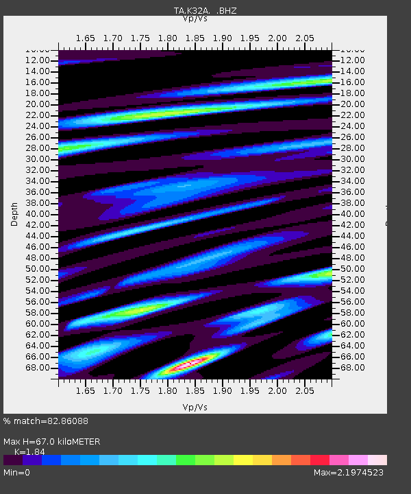
| Estimated Moho Depth: |
67.0 km |
| Estimated Crust Vp/Vs: |
1.84 |
| Assumed Crust Vp: |
6.498 km/s |
| Estimated Crust Vs: |
3.531 km/s |
| Estimated Crust Poisson's Ratio: |
0.29 |
|
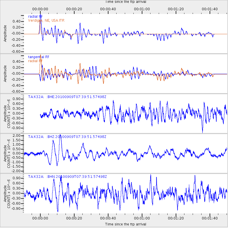
| Radial Match: |
82.86088 % |
| Radial Bump: |
400 |
| Transverse Match: |
75.05916 % |
| Transverse Bump: |
400 |
| SOD ConfigId: |
319893 |
| Insert Time: |
2011-01-13 09:56:48.327 +0000 |
| GWidth: |
2.5 |
| Max Bumps: |
400 |
| Tol: |
0.001 |
|
Signal To Noise
| Channel | StoN | STA | LTA |
| TA:K32A: :BHZ:20100909T07:39:51.57498Z | 3.0464075 | 2.1984152E-7 | 7.216419E-8 |
| TA:K32A: :BHN:20100909T07:39:51.57498Z | 1.1303992 | 1.8721424E-7 | 1.6561779E-7 |
| TA:K32A: :BHE:20100909T07:39:51.57498Z | 1.1127297 | 1.595912E-7 | 1.4342315E-7 |
| Arrivals |
| Ps | 8.9 SECOND |
| PpPs | 29 SECOND |
| PsPs/PpSs | 37 SECOND |


