You are here: Home > Network List > TA - USArray Transportable Network (new EarthScope stations) Stations List
> Station K31A O'Neill, NE, USA > Earthquake Result Viewer
K31A O'Neill, NE, USA - Earthquake Result Viewer
| Earthquake location: |
Near Coast Of Central Chile |
| Earthquake latitude/longitude: |
-37.0/-73.4 |
| Earthquake time(UTC): |
2010/09/09 (252) 07:28:01 GMT |
| Earthquake Depth: |
16 km |
| Earthquake Magnitude: |
5.8 MB, 6.0 MS, 6.2 MW, 6.2 MW |
| Earthquake Catalog/Contributor: |
WHDF/NEIC |
|
| Network: |
TA USArray Transportable Network (new EarthScope stations) |
| Station: |
K31A O'Neill, NE, USA |
| Lat/Lon: |
42.62 N/98.75 W |
| Elevation: |
580 m |
|
| Distance: |
82.6 deg |
| Az: |
341.422 deg |
| Baz: |
159.793 deg |
| Ray Param: |
0.04677904 |
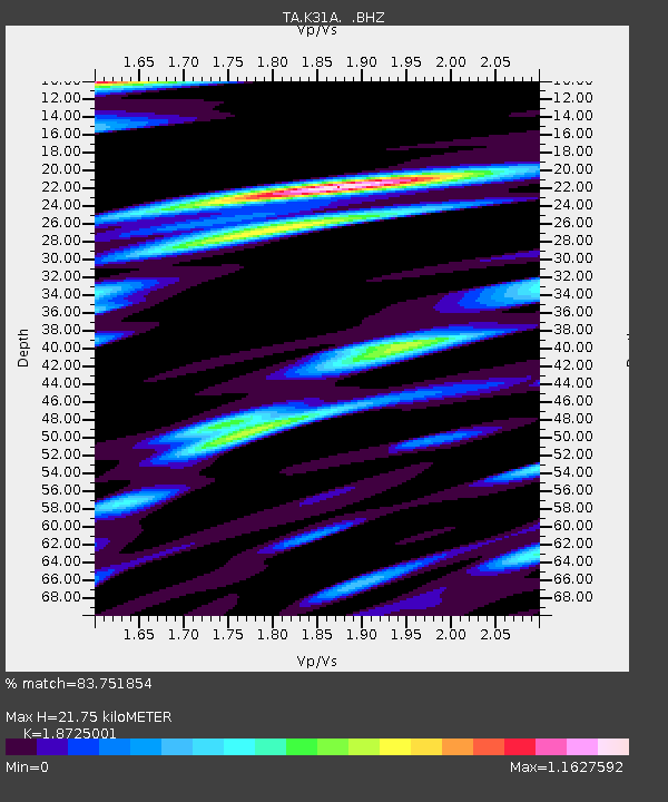
| Estimated Moho Depth: |
21.75 km |
| Estimated Crust Vp/Vs: |
1.87 |
| Assumed Crust Vp: |
6.53 km/s |
| Estimated Crust Vs: |
3.488 km/s |
| Estimated Crust Poisson's Ratio: |
0.30 |
|
| Radial Match: |
83.751854 % |
| Radial Bump: |
400 |
| Transverse Match: |
81.18686 % |
| Transverse Bump: |
400 |
| SOD ConfigId: |
319893 |
| Insert Time: |
2011-01-13 09:58:40.692 +0000 |
| GWidth: |
2.5 |
| Max Bumps: |
400 |
| Tol: |
0.001 |
|
Signal To Noise
| Channel | StoN | STA | LTA |
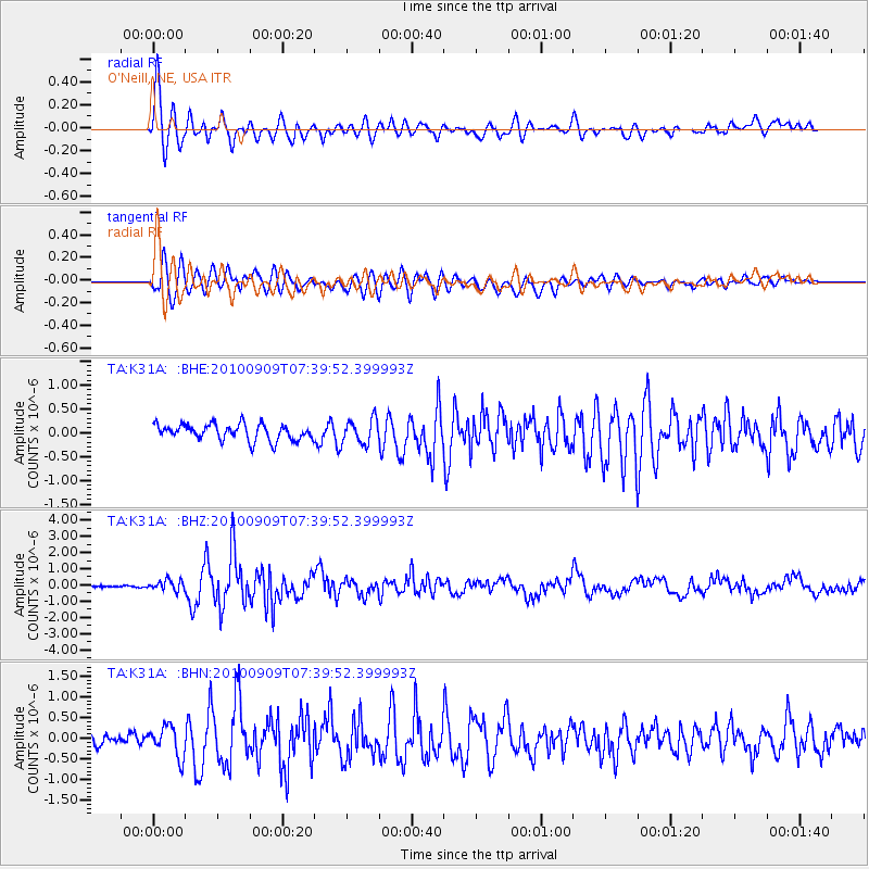
| TA:K31A: :BHZ:20100909T07:39:52.399993Z | 5.067988 | 3.19228E-7 | 6.29891E-8 |
| TA:K31A: :BHN:20100909T07:39:52.399993Z | 2.337318 | 3.6600417E-7 | 1.5659153E-7 |
| TA:K31A: :BHE:20100909T07:39:52.399993Z | 1.5283675 | 2.5669394E-7 | 1.67953E-7 |
| Arrivals |
| Ps | 3.0 SECOND |
| PpPs | 9.3 SECOND |
| PsPs/PpSs | 12 SECOND |


