You are here: Home > Network List > TA - USArray Transportable Network (new EarthScope stations) Stations List
> Station E35A Pequot Lakes, MN, USA > Earthquake Result Viewer
E35A Pequot Lakes, MN, USA - Earthquake Result Viewer
| Earthquake location: |
Near Coast Of Central Chile |
| Earthquake latitude/longitude: |
-37.0/-73.4 |
| Earthquake time(UTC): |
2010/09/09 (252) 07:28:01 GMT |
| Earthquake Depth: |
16 km |
| Earthquake Magnitude: |
5.8 MB, 6.0 MS, 6.2 MW, 6.2 MW |
| Earthquake Catalog/Contributor: |
WHDF/NEIC |
|
| Network: |
TA USArray Transportable Network (new EarthScope stations) |
| Station: |
E35A Pequot Lakes, MN, USA |
| Lat/Lon: |
46.56 N/94.40 W |
| Elevation: |
409 m |
|
| Distance: |
85.3 deg |
| Az: |
345.639 deg |
| Baz: |
163.284 deg |
| Ray Param: |
0.044835154 |
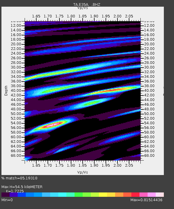
| Estimated Moho Depth: |
54.5 km |
| Estimated Crust Vp/Vs: |
1.72 |
| Assumed Crust Vp: |
6.419 km/s |
| Estimated Crust Vs: |
3.727 km/s |
| Estimated Crust Poisson's Ratio: |
0.25 |
|
| Radial Match: |
85.19318 % |
| Radial Bump: |
400 |
| Transverse Match: |
76.77696 % |
| Transverse Bump: |
400 |
| SOD ConfigId: |
319893 |
| Insert Time: |
2011-01-13 09:58:59.786 +0000 |
| GWidth: |
2.5 |
| Max Bumps: |
400 |
| Tol: |
0.001 |
|

Signal To Noise
| Channel | StoN | STA | LTA |
| TA:E35A: :BHZ:20100909T07:40:06.350005Z | 2.6539314 | 3.0209137E-7 | 1.13827866E-7 |
| TA:E35A: :BHN:20100909T07:40:06.350005Z | 0.7122627 | 8.085747E-8 | 1.1352197E-7 |
| TA:E35A: :BHE:20100909T07:40:06.350005Z | 1.2537401 | 8.9659174E-8 | 7.151336E-8 |
| Arrivals |
| Ps | 6.3 SECOND |
| PpPs | 23 SECOND |
| PsPs/PpSs | 29 SECOND |


