You are here: Home > Network List > TX - Texas Seismological Network Stations List
> Station PLPT Palo Pinto > Earthquake Result Viewer
PLPT Palo Pinto - Earthquake Result Viewer
| Earthquake location: |
Western Brazil |
| Earthquake latitude/longitude: |
-8.2/-71.4 |
| Earthquake time(UTC): |
2024/01/28 (028) 09:38:56 GMT |
| Earthquake Depth: |
609 km |
| Earthquake Magnitude: |
6.5 Mww |
| Earthquake Catalog/Contributor: |
NEIC PDE/us |
|
| Network: |
TX Texas Seismological Network |
| Station: |
PLPT Palo Pinto |
| Lat/Lon: |
32.81 N/98.32 W |
| Elevation: |
336 m |
|
| Distance: |
48.2 deg |
| Az: |
329.209 deg |
| Baz: |
143.006 deg |
| Ray Param: |
0.06656821 |
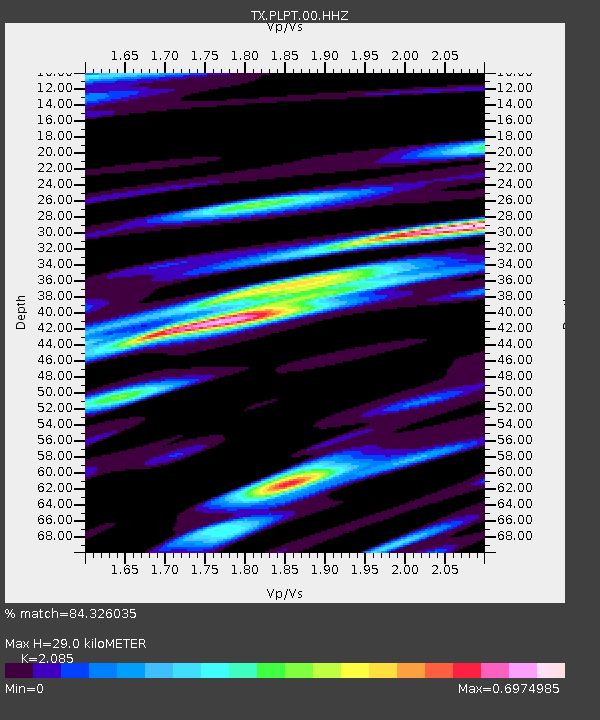
| Estimated Moho Depth: |
29.0 km |
| Estimated Crust Vp/Vs: |
2.09 |
| Assumed Crust Vp: |
6.426 km/s |
| Estimated Crust Vs: |
3.082 km/s |
| Estimated Crust Poisson's Ratio: |
0.35 |
|
| Radial Match: |
84.326035 % |
| Radial Bump: |
342 |
| Transverse Match: |
70.61828 % |
| Transverse Bump: |
390 |
| SOD ConfigId: |
33437571 |
| Insert Time: |
2024-02-11 10:10:45.967 +0000 |
| GWidth: |
2.5 |
| Max Bumps: |
400 |
| Tol: |
0.001 |
|

Signal To Noise
| Channel | StoN | STA | LTA |
| TX:PLPT:00:HHZ:20240128T09:46:12.500011Z | 7.314626 | 9.3243415E-7 | 1.2747529E-7 |
| TX:PLPT:00:HH1:20240128T09:46:12.500011Z | 2.2853997 | 2.0838135E-7 | 9.1179395E-8 |
| TX:PLPT:00:HH2:20240128T09:46:12.500011Z | 2.5754585 | 3.0950315E-7 | 1.20174E-7 |
| Arrivals |
| Ps | 5.1 SECOND |
| PpPs | 13 SECOND |
| PsPs/PpSs | 18 SECOND |


