You are here: Home > Network List > TA - USArray Transportable Network (new EarthScope stations) Stations List
> Station D35A Remer, MN, USA > Earthquake Result Viewer
D35A Remer, MN, USA - Earthquake Result Viewer
| Earthquake location: |
Near Coast Of Central Chile |
| Earthquake latitude/longitude: |
-37.0/-73.4 |
| Earthquake time(UTC): |
2010/09/09 (252) 07:28:01 GMT |
| Earthquake Depth: |
16 km |
| Earthquake Magnitude: |
5.8 MB, 6.0 MS, 6.2 MW, 6.2 MW |
| Earthquake Catalog/Contributor: |
WHDF/NEIC |
|
| Network: |
TA USArray Transportable Network (new EarthScope stations) |
| Station: |
D35A Remer, MN, USA |
| Lat/Lon: |
47.08 N/94.05 W |
| Elevation: |
427 m |
|
| Distance: |
85.8 deg |
| Az: |
346.021 deg |
| Baz: |
163.569 deg |
| Ray Param: |
0.044524368 |
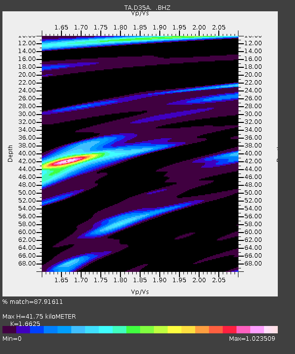
| Estimated Moho Depth: |
41.75 km |
| Estimated Crust Vp/Vs: |
1.66 |
| Assumed Crust Vp: |
6.419 km/s |
| Estimated Crust Vs: |
3.861 km/s |
| Estimated Crust Poisson's Ratio: |
0.22 |
|
| Radial Match: |
87.91611 % |
| Radial Bump: |
400 |
| Transverse Match: |
58.897076 % |
| Transverse Bump: |
400 |
| SOD ConfigId: |
319893 |
| Insert Time: |
2011-01-13 09:59:12.939 +0000 |
| GWidth: |
2.5 |
| Max Bumps: |
400 |
| Tol: |
0.001 |
|

Signal To Noise
| Channel | StoN | STA | LTA |
| TA:D35A: :BHZ:20100909T07:40:08.500029Z | 3.9068847 | 3.4376677E-7 | 8.7989996E-8 |
| TA:D35A: :BHN:20100909T07:40:08.500029Z | 1.7913249 | 1.3472E-7 | 7.52069E-8 |
| TA:D35A: :BHE:20100909T07:40:08.500029Z | 0.8461069 | 1.1020234E-7 | 1.3024636E-7 |
| Arrivals |
| Ps | 4.4 SECOND |
| PpPs | 17 SECOND |
| PsPs/PpSs | 21 SECOND |


