You are here: Home > Network List > TX - Texas Seismological Network Stations List
> Station MB05 Klondike > Earthquake Result Viewer
MB05 Klondike - Earthquake Result Viewer
| Earthquake location: |
Western Brazil |
| Earthquake latitude/longitude: |
-8.2/-71.4 |
| Earthquake time(UTC): |
2024/01/28 (028) 09:38:56 GMT |
| Earthquake Depth: |
609 km |
| Earthquake Magnitude: |
6.5 Mww |
| Earthquake Catalog/Contributor: |
NEIC PDE/us |
|
| Network: |
TX Texas Seismological Network |
| Station: |
MB05 Klondike |
| Lat/Lon: |
32.63 N/101.86 W |
| Elevation: |
882 m |
|
| Distance: |
49.9 deg |
| Az: |
325.982 deg |
| Baz: |
138.984 deg |
| Ray Param: |
0.065513216 |
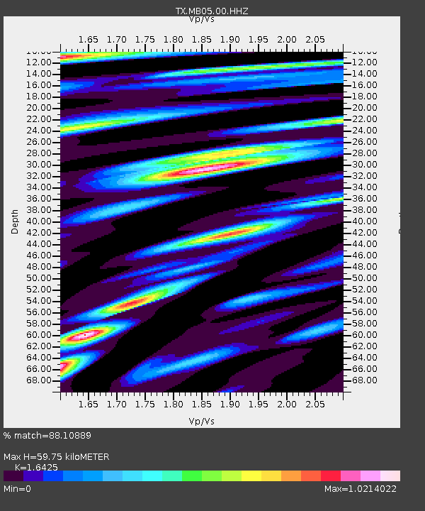
| Estimated Moho Depth: |
59.75 km |
| Estimated Crust Vp/Vs: |
1.64 |
| Assumed Crust Vp: |
6.426 km/s |
| Estimated Crust Vs: |
3.912 km/s |
| Estimated Crust Poisson's Ratio: |
0.21 |
|
| Radial Match: |
88.10889 % |
| Radial Bump: |
353 |
| Transverse Match: |
84.05564 % |
| Transverse Bump: |
400 |
| SOD ConfigId: |
33437571 |
| Insert Time: |
2024-02-11 10:11:42.970 +0000 |
| GWidth: |
2.5 |
| Max Bumps: |
400 |
| Tol: |
0.001 |
|

Signal To Noise
| Channel | StoN | STA | LTA |
| TX:MB05:00:HHZ:20240128T09:46:25.217998Z | 21.018904 | 2.9496978E-6 | 1.4033547E-7 |
| TX:MB05:00:HHN:20240128T09:46:25.217998Z | 1.7660277 | 2.0423437E-7 | 1.15646195E-7 |
| TX:MB05:00:HHE:20240128T09:46:25.217998Z | 4.2021065 | 4.51694E-7 | 1.0749228E-7 |
| Arrivals |
| Ps | 6.3 SECOND |
| PpPs | 23 SECOND |
| PsPs/PpSs | 30 SECOND |


