You are here: Home > Network List > US - United States National Seismic Network Stations List
> Station TZTN Tazewell, Tennessee, USA > Earthquake Result Viewer
TZTN Tazewell, Tennessee, USA - Earthquake Result Viewer

| Earthquake location: |
Western Brazil |
| Earthquake latitude/longitude: |
-8.2/-71.4 |
| Earthquake time(UTC): |
2024/01/28 (028) 09:38:56 GMT |
| Earthquake Depth: |
609 km |
| Earthquake Magnitude: |
6.5 Mww |
| Earthquake Catalog/Contributor: |
NEIC PDE/us |
|
| Network: |
US United States National Seismic Network |
| Station: |
TZTN Tazewell, Tennessee, USA |
| Lat/Lon: |
36.54 N/83.55 W |
| Elevation: |
394 m |
|
| Distance: |
46.0 deg |
| Az: |
346.329 deg |
| Baz: |
163.111 deg |
| Ray Param: |
0.067905985 |
| Estimated Moho Depth: |
14.25 km |
| Estimated Crust Vp/Vs: |
1.94 |
| Assumed Crust Vp: |
6.476 km/s |
| Estimated Crust Vs: |
3.334 km/s |
| Estimated Crust Poisson's Ratio: |
0.32 |
|
| Radial Match: |
80.73797 % |
| Radial Bump: |
400 |
| Transverse Match: |
63.31995 % |
| Transverse Bump: |
400 |
| SOD ConfigId: |
33437571 |
| Insert Time: |
2024-02-11 10:14:03.503 +0000 |
| GWidth: |
2.5 |
| Max Bumps: |
400 |
| Tol: |
0.001 |
|
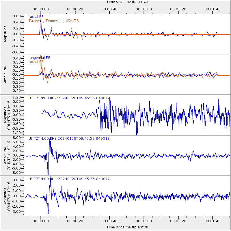
Signal To Noise
| Channel | StoN | STA | LTA |
| US:TZTN:00:BHZ:20240128T09:45:55.84901Z | 14.758831 | 2.487032E-6 | 1.6851145E-7 |
| US:TZTN:00:BH1:20240128T09:45:55.84901Z | 6.6729827 | 9.895851E-7 | 1.4829727E-7 |
| US:TZTN:00:BH2:20240128T09:45:55.84901Z | 2.1839476 | 3.2251342E-7 | 1.4767453E-7 |
| Arrivals |
| Ps | 2.2 SECOND |
| PpPs | 6.1 SECOND |
| PsPs/PpSs | 8.3 SECOND |


