You are here: Home > Network List > TA - USArray Transportable Network (new EarthScope stations) Stations List
> Station TOLK Toolik Lake Research Station, AK, USA > Earthquake Result Viewer
TOLK Toolik Lake Research Station, AK, USA - Earthquake Result Viewer
| Earthquake location: |
Northern Molucca Sea |
| Earthquake latitude/longitude: |
1.7/126.4 |
| Earthquake time(UTC): |
2019/03/24 (083) 04:37:34 GMT |
| Earthquake Depth: |
37 km |
| Earthquake Magnitude: |
6.1 Mww |
| Earthquake Catalog/Contributor: |
NEIC PDE/us |
|
| Network: |
TA USArray Transportable Network (new EarthScope stations) |
| Station: |
TOLK Toolik Lake Research Station, AK, USA |
| Lat/Lon: |
68.64 N/149.57 W |
| Elevation: |
760 m |
|
| Distance: |
86.2 deg |
| Az: |
21.415 deg |
| Baz: |
265.039 deg |
| Ray Param: |
0.044150084 |
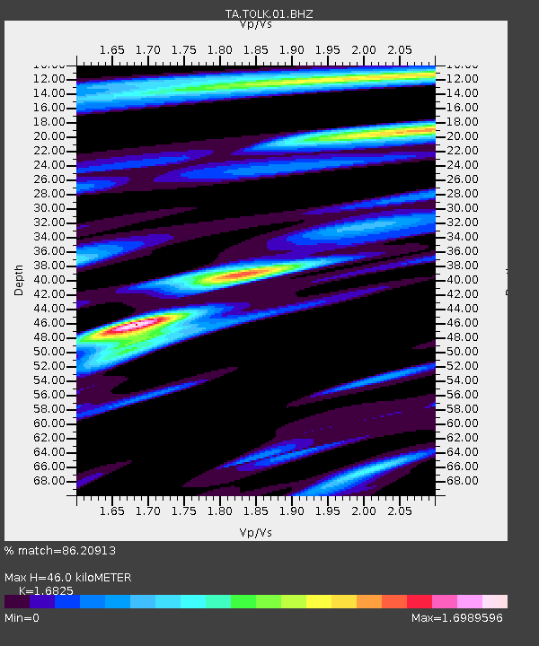
| Estimated Moho Depth: |
46.0 km |
| Estimated Crust Vp/Vs: |
1.68 |
| Assumed Crust Vp: |
6.316 km/s |
| Estimated Crust Vs: |
3.754 km/s |
| Estimated Crust Poisson's Ratio: |
0.23 |
|
| Radial Match: |
86.20913 % |
| Radial Bump: |
400 |
| Transverse Match: |
76.29558 % |
| Transverse Bump: |
400 |
| SOD ConfigId: |
3338192 |
| Insert Time: |
2019-04-07 05:05:44.997 +0000 |
| GWidth: |
2.5 |
| Max Bumps: |
400 |
| Tol: |
0.001 |
|

Signal To Noise
| Channel | StoN | STA | LTA |
| TA:TOLK:01:BHZ:20190324T04:49:41.399993Z | 6.444948 | 1.182852E-6 | 1.8353164E-7 |
| TA:TOLK:01:BHN:20190324T04:49:41.399993Z | 1.7618307 | 3.198901E-7 | 1.8156686E-7 |
| TA:TOLK:01:BHE:20190324T04:49:41.399993Z | 1.2968525 | 2.8806735E-7 | 2.221281E-7 |
| Arrivals |
| Ps | 5.1 SECOND |
| PpPs | 19 SECOND |
| PsPs/PpSs | 24 SECOND |


