You are here: Home > Network List > AK - Alaska Regional Network Stations List
> Station MDM Murphy Dome > Earthquake Result Viewer
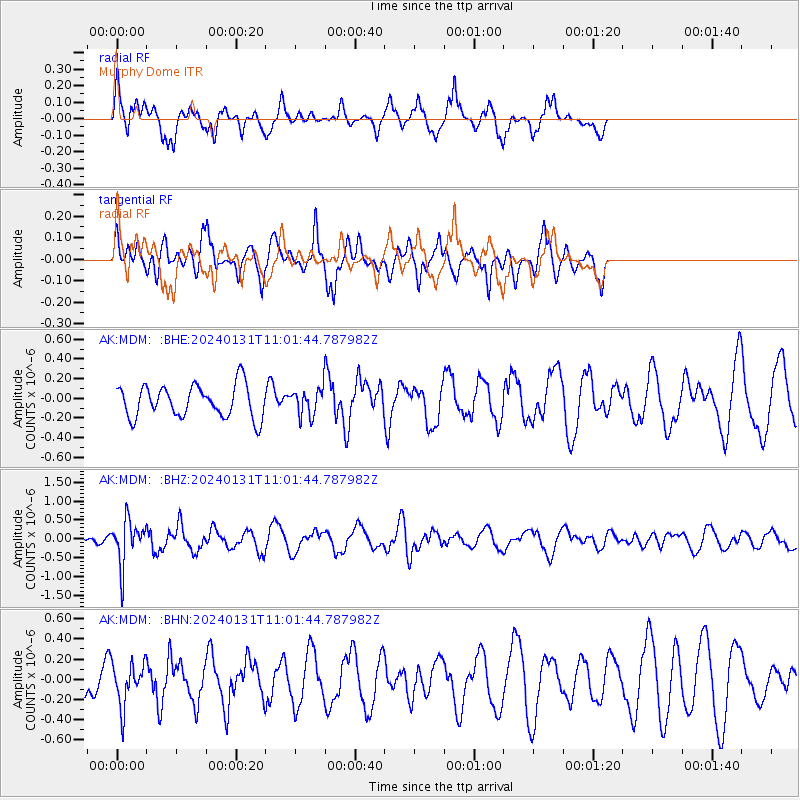
MDM Murphy Dome - Earthquake Result Viewer
*The percent match for this event was below the threshold and hence no stack was calculated.
| Earthquake location: |
South Of Fiji Islands |
| Earthquake latitude/longitude: |
-22.8/-177.1 |
| Earthquake time(UTC): |
2024/01/31 (031) 10:49:36 GMT |
| Earthquake Depth: |
185 km |
| Earthquake Magnitude: |
5.8 mww |
| Earthquake Catalog/Contributor: |
NEIC PDE/us |
|
| Network: |
AK Alaska Regional Network |
| Station: |
MDM Murphy Dome |
| Lat/Lon: |
64.96 N/148.23 W |
| Elevation: |
634 m |
|
| Distance: |
90.3 deg |
| Az: |
11.873 deg |
| Baz: |
206.487 deg |
| Ray Param: |
$rayparam |
*The percent match for this event was below the threshold and hence was not used in the summary stack. |
|
| Radial Match: |
66.879364 % |
| Radial Bump: |
365 |
| Transverse Match: |
63.94827 % |
| Transverse Bump: |
351 |
| SOD ConfigId: |
33437571 |
| Insert Time: |
2024-02-14 10:53:39.024 +0000 |
| GWidth: |
2.5 |
| Max Bumps: |
400 |
| Tol: |
0.001 |
|
Signal To Noise
| Channel | StoN | STA | LTA |
| AK:MDM: :BHZ:20240131T11:01:44.787982Z | 5.535028 | 5.865982E-7 | 1.0597927E-7 |
| AK:MDM: :BHN:20240131T11:01:44.787982Z | 1.255743 | 2.1339038E-7 | 1.6993157E-7 |
| AK:MDM: :BHE:20240131T11:01:44.787982Z | 0.7910453 | 1.2992894E-7 | 1.6424968E-7 |
| Arrivals |
| Ps | |
| PpPs | |
| PsPs/PpSs | |


