You are here: Home > Network List > CI - Caltech Regional Seismic Network Stations List
> Station DGR Domenigoni Reservoir, California, USA > Earthquake Result Viewer
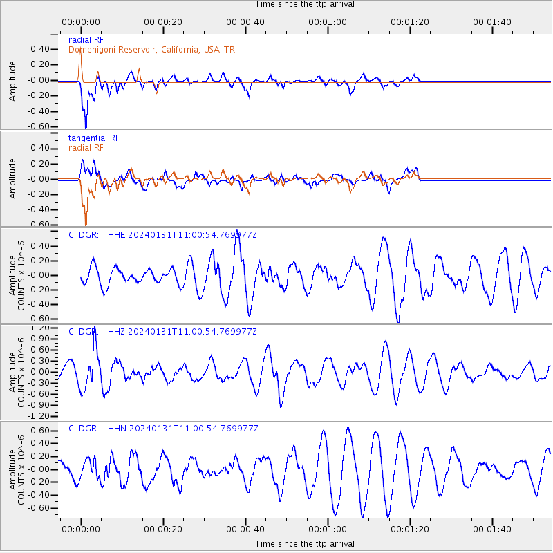
DGR Domenigoni Reservoir, California, USA - Earthquake Result Viewer
*The percent match for this event was below the threshold and hence no stack was calculated.
| Earthquake location: |
South Of Fiji Islands |
| Earthquake latitude/longitude: |
-22.8/-177.1 |
| Earthquake time(UTC): |
2024/01/31 (031) 10:49:36 GMT |
| Earthquake Depth: |
185 km |
| Earthquake Magnitude: |
5.8 mww |
| Earthquake Catalog/Contributor: |
NEIC PDE/us |
|
| Network: |
CI Caltech Regional Seismic Network |
| Station: |
DGR Domenigoni Reservoir, California, USA |
| Lat/Lon: |
33.65 N/117.01 W |
| Elevation: |
609 m |
|
| Distance: |
80.2 deg |
| Az: |
47.229 deg |
| Baz: |
234.282 deg |
| Ray Param: |
$rayparam |
*The percent match for this event was below the threshold and hence was not used in the summary stack. |
|
| Radial Match: |
75.7131 % |
| Radial Bump: |
400 |
| Transverse Match: |
32.480263 % |
| Transverse Bump: |
400 |
| SOD ConfigId: |
33437571 |
| Insert Time: |
2024-02-14 11:00:27.160 +0000 |
| GWidth: |
2.5 |
| Max Bumps: |
400 |
| Tol: |
0.001 |
|
Signal To Noise
| Channel | StoN | STA | LTA |
| CI:DGR: :HHZ:20240131T11:00:54.769977Z | 2.7897553 | 5.2748857E-7 | 1.8908058E-7 |
| CI:DGR: :HHN:20240131T11:00:54.769977Z | 0.72994405 | 1.5072317E-7 | 2.0648592E-7 |
| CI:DGR: :HHE:20240131T11:00:54.769977Z | 2.1234088 | 2.234459E-7 | 1.052298E-7 |
| Arrivals |
| Ps | |
| PpPs | |
| PsPs/PpSs | |


