CRY AZ.CRY - Earthquake Result Viewer
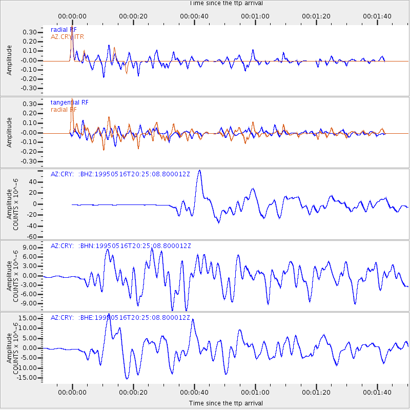
Earthquake location: Southeast Of Loyalty Islands
Earthquake latitude/longitude: -23.0/169.9
Earthquake time(UTC): 1995/05/16 (136) 20:12:45 GMT
Earthquake Depth: 33 km
Earthquake Magnitude: 6.8 MB, 7.7 MS, 7.7 UNKNOWN, 7.7 MW
Earthquake Catalog/Contributor: WHDF/NEIC
Network: AZ ANZA Regional Network
Station: CRY AZ.CRY
Lat/Lon: 33.57 N/116.74 W
Elevation: 1128 m
Distance: 89.6 deg
Az: 53.135 deg
Baz: 241.985 deg
Ray Param: 0.041726142
Estimated Moho Depth: 26.0 km
Estimated Crust Vp/Vs: 1.96
Assumed Crust Vp: 6.264 km/s
Estimated Crust Vs: 3.204 km/s
Estimated Crust Poisson's Ratio: 0.32
Radial Match: 93.38821 %
Radial Bump: 400
Transverse Match: 87.520645 %
Transverse Bump: 400
SOD ConfigId: 6273
Insert Time: 2010-02-26 18:56:53.991 +0000
GWidth: 2.5
Max Bumps: 400
Tol: 0.001

Signal To Noise

ChannelStoNSTALTA
AZ:CRY: :BHN:19950516T20:25:08.800012Z6.53115469.0998685E-71.3933017E-7
AZ:CRY: :BHE:19950516T20:25:08.800012Z5.4890191.3877665E-62.5282594E-7
AZ:CRY: :BHZ:19950516T20:25:08.800012Z34.7587665.7182187E-61.6451158E-7
Arrivals
Ps4.0 SECOND
PpPs12 SECOND
PsPs/PpSs16 SECOND