You are here: Home > Network List > WW - Idaho Seismic Network () Stations List
> Station BILL Emerald Creek, Idaho > Earthquake Result Viewer
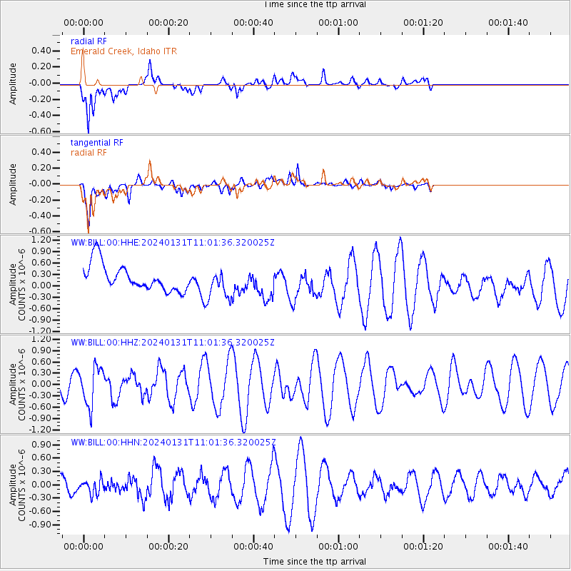
BILL Emerald Creek, Idaho - Earthquake Result Viewer
*The percent match for this event was below the threshold and hence no stack was calculated.
| Earthquake location: |
South Of Fiji Islands |
| Earthquake latitude/longitude: |
-22.8/-177.1 |
| Earthquake time(UTC): |
2024/01/31 (031) 10:49:36 GMT |
| Earthquake Depth: |
185 km |
| Earthquake Magnitude: |
5.8 mww |
| Earthquake Catalog/Contributor: |
NEIC PDE/us |
|
| Network: |
WW Idaho Seismic Network () |
| Station: |
BILL Emerald Creek, Idaho |
| Lat/Lon: |
47.03 N/116.34 W |
| Elevation: |
866 m |
|
| Distance: |
88.5 deg |
| Az: |
36.678 deg |
| Baz: |
233.67 deg |
| Ray Param: |
$rayparam |
*The percent match for this event was below the threshold and hence was not used in the summary stack. |
|
| Radial Match: |
47.731163 % |
| Radial Bump: |
400 |
| Transverse Match: |
66.981705 % |
| Transverse Bump: |
400 |
| SOD ConfigId: |
33437571 |
| Insert Time: |
2024-02-14 11:14:50.630 +0000 |
| GWidth: |
2.5 |
| Max Bumps: |
400 |
| Tol: |
0.001 |
|
Signal To Noise
| Channel | StoN | STA | LTA |
| WW:BILL:00:HHZ:20240131T11:01:36.320025Z | 1.8915709 | 5.116155E-7 | 2.7047122E-7 |
| WW:BILL:00:HHN:20240131T11:01:36.320025Z | 0.45075673 | 1.660428E-7 | 3.6836454E-7 |
| WW:BILL:00:HHE:20240131T11:01:36.320025Z | 1.1453327 | 3.9591362E-7 | 3.4567563E-7 |
| Arrivals |
| Ps | |
| PpPs | |
| PsPs/PpSs | |


