You are here: Home > Network List > UU - University of Utah Regional Network Stations List
> Station FOR2 Blundell East, UT, USA > Earthquake Result Viewer
FOR2 Blundell East, UT, USA - Earthquake Result Viewer
| Earthquake location: |
South Of Mariana Islands |
| Earthquake latitude/longitude: |
12.4/143.5 |
| Earthquake time(UTC): |
2024/02/04 (035) 09:50:42 GMT |
| Earthquake Depth: |
10 km |
| Earthquake Magnitude: |
5.7 Mi |
| Earthquake Catalog/Contributor: |
NEIC PDE/pt |
|
| Network: |
UU University of Utah Regional Network |
| Station: |
FOR2 Blundell East, UT, USA |
| Lat/Lon: |
38.49 N/112.87 W |
| Elevation: |
1760 m |
|
| Distance: |
92.8 deg |
| Az: |
49.773 deg |
| Baz: |
288.061 deg |
| Ray Param: |
0.04139303 |
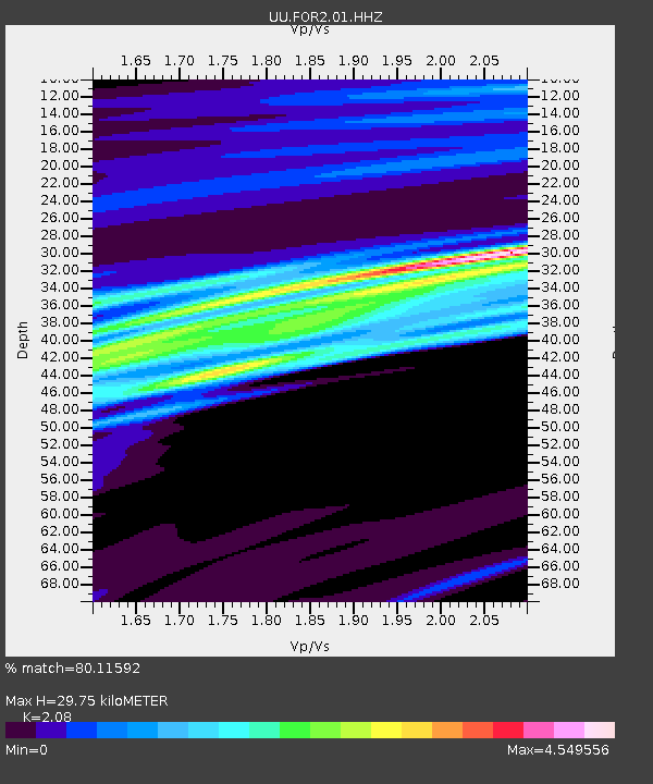
| Estimated Moho Depth: |
29.75 km |
| Estimated Crust Vp/Vs: |
2.08 |
| Assumed Crust Vp: |
6.276 km/s |
| Estimated Crust Vs: |
3.017 km/s |
| Estimated Crust Poisson's Ratio: |
0.35 |
|
| Radial Match: |
80.11592 % |
| Radial Bump: |
400 |
| Transverse Match: |
69.519424 % |
| Transverse Bump: |
400 |
| SOD ConfigId: |
33437571 |
| Insert Time: |
2024-02-18 10:09:55.790 +0000 |
| GWidth: |
2.5 |
| Max Bumps: |
400 |
| Tol: |
0.001 |
|

Signal To Noise
| Channel | StoN | STA | LTA |
| UU:FOR2:01:HHZ:20240204T10:03:22.960022Z | 0.7050597 | 3.247609E-7 | 4.6061473E-7 |
| UU:FOR2:01:HHN:20240204T10:03:22.960022Z | 0.8531194 | 1.5851053E-6 | 1.8580113E-6 |
| UU:FOR2:01:HHE:20240204T10:03:22.960022Z | 0.7323718 | 6.1231265E-7 | 8.36068E-7 |
| Arrivals |
| Ps | 5.2 SECOND |
| PpPs | 14 SECOND |
| PsPs/PpSs | 20 SECOND |


