You are here: Home > Network List > UW - Pacific Northwest Regional Seismic Network Stations List
> Station UMAT Pilot Rock, OR, USA > Earthquake Result Viewer
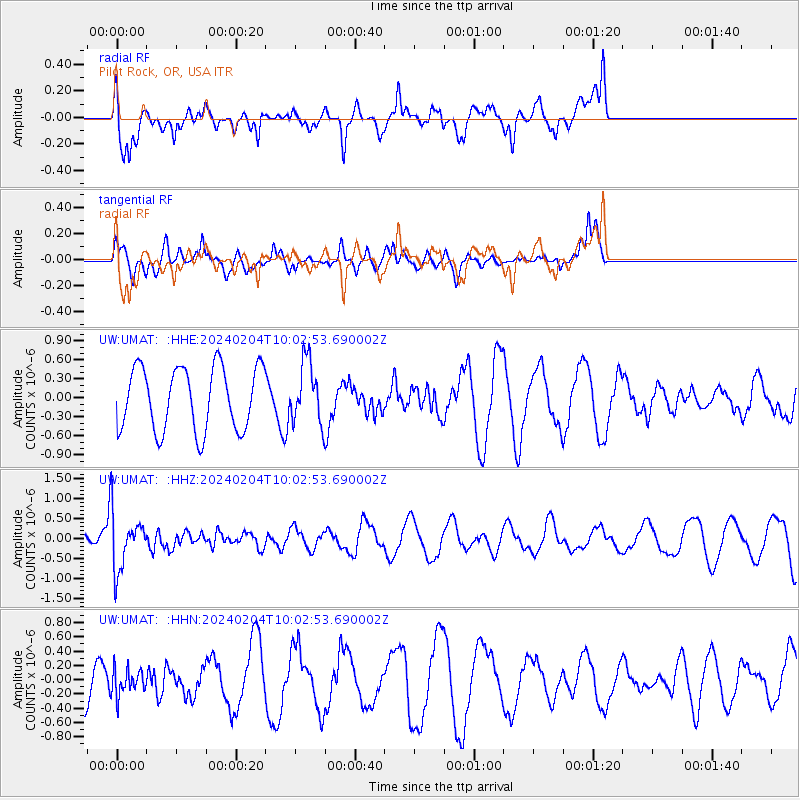
UMAT Pilot Rock, OR, USA - Earthquake Result Viewer
*The percent match for this event was below the threshold and hence no stack was calculated.
| Earthquake location: |
South Of Mariana Islands |
| Earthquake latitude/longitude: |
12.4/143.5 |
| Earthquake time(UTC): |
2024/02/04 (035) 09:50:42 GMT |
| Earthquake Depth: |
10 km |
| Earthquake Magnitude: |
5.7 Mi |
| Earthquake Catalog/Contributor: |
NEIC PDE/pt |
|
| Network: |
UW Pacific Northwest Regional Seismic Network |
| Station: |
UMAT Pilot Rock, OR, USA |
| Lat/Lon: |
45.29 N/118.96 W |
| Elevation: |
1318 m |
|
| Distance: |
86.6 deg |
| Az: |
44.511 deg |
| Baz: |
283.972 deg |
| Ray Param: |
$rayparam |
*The percent match for this event was below the threshold and hence was not used in the summary stack. |
|
| Radial Match: |
83.62875 % |
| Radial Bump: |
400 |
| Transverse Match: |
62.11693 % |
| Transverse Bump: |
390 |
| SOD ConfigId: |
33437571 |
| Insert Time: |
2024-02-18 10:12:35.487 +0000 |
| GWidth: |
2.5 |
| Max Bumps: |
400 |
| Tol: |
0.001 |
|
Signal To Noise
| Channel | StoN | STA | LTA |
| UW:UMAT: :HHZ:20240204T10:02:53.690002Z | 2.619601 | 6.9827087E-7 | 2.665562E-7 |
| UW:UMAT: :HHN:20240204T10:02:53.690002Z | 0.40302166 | 1.8460177E-7 | 4.580443E-7 |
| UW:UMAT: :HHE:20240204T10:02:53.690002Z | 0.957936 | 4.768788E-7 | 4.978191E-7 |
| Arrivals |
| Ps | |
| PpPs | |
| PsPs/PpSs | |


