You are here: Home > Network List > WW - Idaho Seismic Network () Stations List
> Station BILL Emerald Creek, Idaho > Earthquake Result Viewer
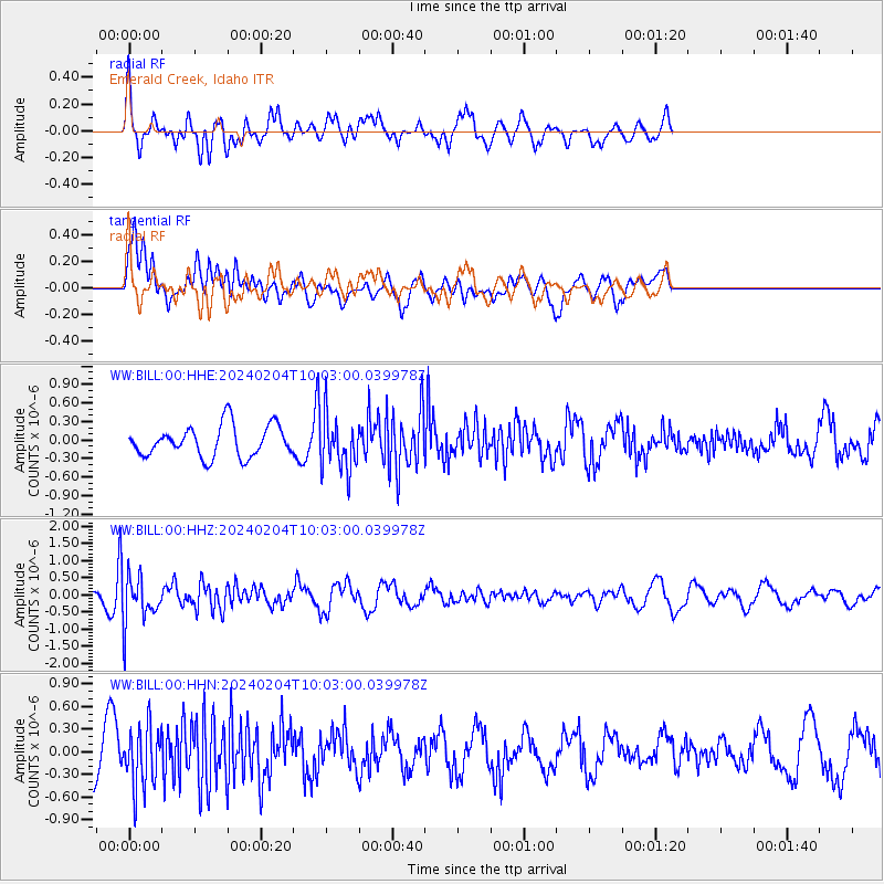
BILL Emerald Creek, Idaho - Earthquake Result Viewer
*The percent match for this event was below the threshold and hence no stack was calculated.
| Earthquake location: |
South Of Mariana Islands |
| Earthquake latitude/longitude: |
12.4/143.5 |
| Earthquake time(UTC): |
2024/02/04 (035) 09:50:42 GMT |
| Earthquake Depth: |
10 km |
| Earthquake Magnitude: |
5.7 Mi |
| Earthquake Catalog/Contributor: |
NEIC PDE/pt |
|
| Network: |
WW Idaho Seismic Network () |
| Station: |
BILL Emerald Creek, Idaho |
| Lat/Lon: |
47.03 N/116.34 W |
| Elevation: |
866 m |
|
| Distance: |
87.9 deg |
| Az: |
42.357 deg |
| Baz: |
285.753 deg |
| Ray Param: |
$rayparam |
*The percent match for this event was below the threshold and hence was not used in the summary stack. |
|
| Radial Match: |
85.48816 % |
| Radial Bump: |
400 |
| Transverse Match: |
59.962967 % |
| Transverse Bump: |
400 |
| SOD ConfigId: |
33437571 |
| Insert Time: |
2024-02-18 10:13:09.640 +0000 |
| GWidth: |
2.5 |
| Max Bumps: |
400 |
| Tol: |
0.001 |
|
Signal To Noise
| Channel | StoN | STA | LTA |
| WW:BILL:00:HHZ:20240204T10:03:00.039978Z | 2.3282208 | 6.881778E-7 | 2.95581E-7 |
| WW:BILL:00:HHN:20240204T10:03:00.039978Z | 1.2971375 | 4.0193632E-7 | 3.0986408E-7 |
| WW:BILL:00:HHE:20240204T10:03:00.039978Z | 1.745267 | 4.3738012E-7 | 2.5060928E-7 |
| Arrivals |
| Ps | |
| PpPs | |
| PsPs/PpSs | |


