You are here: Home > Network List > UW - Pacific Northwest Regional Seismic Network Stations List
> Station IRON Crane, OR, USA > Earthquake Result Viewer
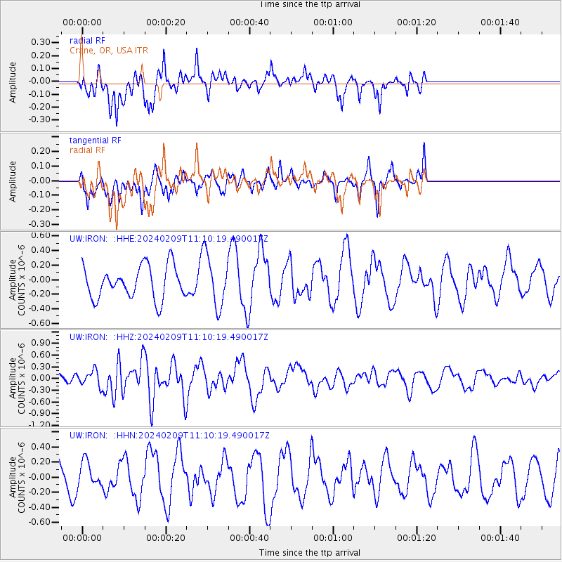
IRON Crane, OR, USA - Earthquake Result Viewer
*The percent match for this event was below the threshold and hence no stack was calculated.
| Earthquake location: |
Kermadec Islands, New Zealand |
| Earthquake latitude/longitude: |
-29.9/-177.3 |
| Earthquake time(UTC): |
2024/02/09 (040) 10:57:48 GMT |
| Earthquake Depth: |
10 km |
| Earthquake Magnitude: |
6.1 mww |
| Earthquake Catalog/Contributor: |
NEIC PDE/us |
|
| Network: |
UW Pacific Northwest Regional Seismic Network |
| Station: |
IRON Crane, OR, USA |
| Lat/Lon: |
43.36 N/118.47 W |
| Elevation: |
1226 m |
|
| Distance: |
90.7 deg |
| Az: |
38.612 deg |
| Baz: |
227.975 deg |
| Ray Param: |
$rayparam |
*The percent match for this event was below the threshold and hence was not used in the summary stack. |
|
| Radial Match: |
74.53365 % |
| Radial Bump: |
399 |
| Transverse Match: |
33.2595 % |
| Transverse Bump: |
329 |
| SOD ConfigId: |
33437571 |
| Insert Time: |
2024-02-23 11:17:53.596 +0000 |
| GWidth: |
2.5 |
| Max Bumps: |
400 |
| Tol: |
0.001 |
|
Signal To Noise
| Channel | StoN | STA | LTA |
| UW:IRON: :HHZ:20240209T11:10:19.490017Z | 1.4113663 | 1.9876938E-7 | 1.4083471E-7 |
| UW:IRON: :HHN:20240209T11:10:19.490017Z | 1.0070834 | 1.6728369E-7 | 1.6610707E-7 |
| UW:IRON: :HHE:20240209T11:10:19.490017Z | 1.6037587 | 3.5546591E-7 | 2.2164552E-7 |
| Arrivals |
| Ps | |
| PpPs | |
| PsPs/PpSs | |


