You are here: Home > Network List > CC - Cascade Chain Volcano Monitoring Stations List
> Station MILD Mildred Point > Earthquake Result Viewer
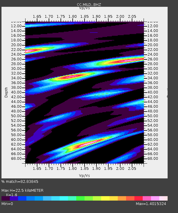
MILD Mildred Point - Earthquake Result Viewer
| Earthquake location: |
Hawaii |
| Earthquake latitude/longitude: |
19.0/-155.5 |
| Earthquake time(UTC): |
2024/02/09 (040) 20:06:30 GMT |
| Earthquake Depth: |
10 km |
| Earthquake Magnitude: |
6.3 Mi |
| Earthquake Catalog/Contributor: |
NEIC PDE/pt |
|
| Network: |
CC Cascade Chain Volcano Monitoring |
| Station: |
MILD Mildred Point |
| Lat/Lon: |
46.81 N/121.78 W |
| Elevation: |
2016 m |
|
| Distance: |
39.1 deg |
| Az: |
37.233 deg |
| Baz: |
236.438 deg |
| Ray Param: |
0.07518947 |
| Estimated Moho Depth: |
22.5 km |
| Estimated Crust Vp/Vs: |
1.60 |
| Assumed Crust Vp: |
6.597 km/s |
| Estimated Crust Vs: |
4.123 km/s |
| Estimated Crust Poisson's Ratio: |
0.18 |
|
| Radial Match: |
82.83845 % |
| Radial Bump: |
400 |
| Transverse Match: |
53.138927 % |
| Transverse Bump: |
400 |
| SOD ConfigId: |
33437571 |
| Insert Time: |
2024-02-23 20:17:00.907 +0000 |
| GWidth: |
2.5 |
| Max Bumps: |
400 |
| Tol: |
0.001 |
|

Signal To Noise
| Channel | StoN | STA | LTA |
| CC:MILD: :BHZ:20240209T20:13:26.640015Z | 6.769058 | 6.830566E-7 | 1.00908665E-7 |
| CC:MILD: :BHN:20240209T20:13:26.640015Z | 1.9042529 | 3.5731205E-7 | 1.8763897E-7 |
| CC:MILD: :BHE:20240209T20:13:26.640015Z | 4.379867 | 5.003029E-7 | 1.1422787E-7 |
| Arrivals |
| Ps | 2.2 SECOND |
| PpPs | 8.1 SECOND |
| PsPs/PpSs | 10 SECOND |


