You are here: Home > Network List > CI - Caltech Regional Seismic Network Stations List
> Station SWS Sam W. Stewart, Westmorland, CA, USA > Earthquake Result Viewer
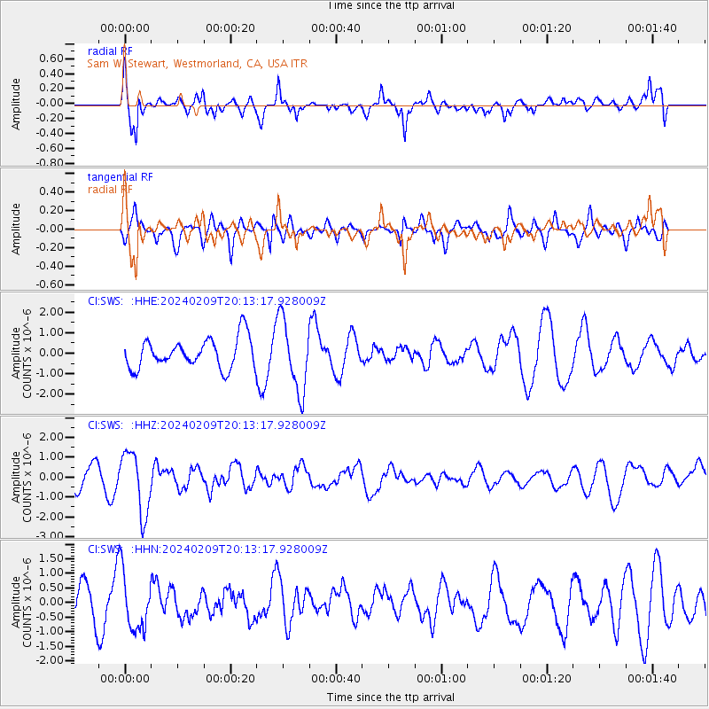
SWS Sam W. Stewart, Westmorland, CA, USA - Earthquake Result Viewer
*The percent match for this event was below the threshold and hence no stack was calculated.
| Earthquake location: |
Hawaii |
| Earthquake latitude/longitude: |
19.0/-155.5 |
| Earthquake time(UTC): |
2024/02/09 (040) 20:06:30 GMT |
| Earthquake Depth: |
10 km |
| Earthquake Magnitude: |
6.3 Mi |
| Earthquake Catalog/Contributor: |
NEIC PDE/pt |
|
| Network: |
CI Caltech Regional Seismic Network |
| Station: |
SWS Sam W. Stewart, Westmorland, CA, USA |
| Lat/Lon: |
32.94 N/115.80 W |
| Elevation: |
140 m |
|
| Distance: |
38.1 deg |
| Az: |
60.651 deg |
| Baz: |
258.688 deg |
| Ray Param: |
$rayparam |
*The percent match for this event was below the threshold and hence was not used in the summary stack. |
|
| Radial Match: |
72.756584 % |
| Radial Bump: |
390 |
| Transverse Match: |
61.17832 % |
| Transverse Bump: |
400 |
| SOD ConfigId: |
33437571 |
| Insert Time: |
2024-02-23 20:19:00.553 +0000 |
| GWidth: |
2.5 |
| Max Bumps: |
400 |
| Tol: |
0.001 |
|
Signal To Noise
| Channel | StoN | STA | LTA |
| CI:SWS: :HHZ:20240209T20:13:17.928009Z | 3.1805062 | 1.5557994E-6 | 4.891672E-7 |
| CI:SWS: :HHN:20240209T20:13:17.928009Z | 1.5103986 | 9.549879E-7 | 6.322754E-7 |
| CI:SWS: :HHE:20240209T20:13:17.928009Z | 2.4082065 | 1.7427504E-6 | 7.236715E-7 |
| Arrivals |
| Ps | |
| PpPs | |
| PsPs/PpSs | |


