You are here: Home > Network List > 2G - Testing of the effectiveness of incorporating seismic data in seismic hazard ass Stations List
> Station IUGFS Indiana Univ Geologic Field Station, Cardwell, MT > Earthquake Result Viewer
IUGFS Indiana Univ Geologic Field Station, Cardwell, MT - Earthquake Result Viewer
| Earthquake location: |
Vanuatu Islands |
| Earthquake latitude/longitude: |
-13.9/167.2 |
| Earthquake time(UTC): |
2014/01/01 (001) 16:03:29 GMT |
| Earthquake Depth: |
187 km |
| Earthquake Magnitude: |
6.5 MWW, 6.5 MWC, 6.6 MWC, 6.6 MI, 6.6 MWB |
| Earthquake Catalog/Contributor: |
NEIC PDE/NEIC COMCAT |
|
| Network: |
2G Testing of the effectiveness of incorporating seismic data in seismic hazard ass |
| Station: |
IUGFS Indiana Univ Geologic Field Station, Cardwell, MT |
| Lat/Lon: |
45.73 N/111.97 W |
| Elevation: |
1634 m |
|
| Distance: |
93.5 deg |
| Az: |
43.844 deg |
| Baz: |
253.838 deg |
| Ray Param: |
0.041133277 |
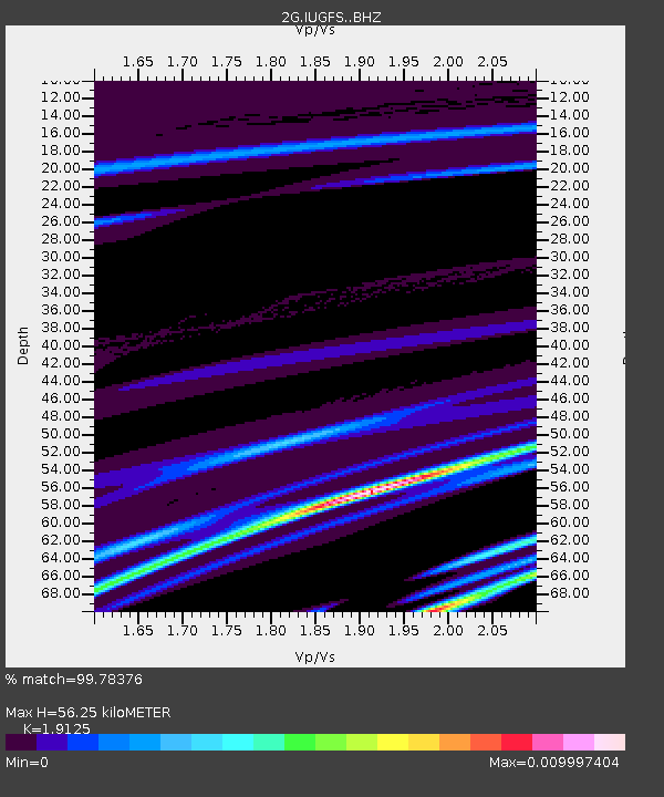
| Estimated Moho Depth: |
56.25 km |
| Estimated Crust Vp/Vs: |
1.91 |
| Assumed Crust Vp: |
6.35 km/s |
| Estimated Crust Vs: |
3.32 km/s |
| Estimated Crust Poisson's Ratio: |
0.31 |
|
| Radial Match: |
99.78376 % |
| Radial Bump: |
30 |
| Transverse Match: |
99.84759 % |
| Transverse Bump: |
21 |
| SOD ConfigId: |
3382691 |
| Insert Time: |
2019-04-09 20:23:12.067 +0000 |
| GWidth: |
2.5 |
| Max Bumps: |
400 |
| Tol: |
0.001 |
|

Signal To Noise
| Channel | StoN | STA | LTA |
| 2G:IUGFS: :BHZ:20140101T16:15:51.799988Z | 2.3718915 | 2.6815317E-7 | 1.1305457E-7 |
| 2G:IUGFS: :BHN:20140101T16:15:51.799988Z | 2.3373828 | 3.1914865E-7 | 1.3654103E-7 |
| 2G:IUGFS: :BHE:20140101T16:15:51.799988Z | 0.72567904 | 2.9894562E-9 | 4.1195296E-9 |
| Arrivals |
| Ps | 8.2 SECOND |
| PpPs | 25 SECOND |
| PsPs/PpSs | 34 SECOND |


