You are here: Home > Network List > UW - Pacific Northwest Regional Seismic Network Stations List
> Station DOTY Weyerhaeuser Tree Farm, Grays Harbor County, WA, USA > Earthquake Result Viewer
DOTY Weyerhaeuser Tree Farm, Grays Harbor County, WA, USA - Earthquake Result Viewer
| Earthquake location: |
Hawaii |
| Earthquake latitude/longitude: |
19.0/-155.5 |
| Earthquake time(UTC): |
2024/02/09 (040) 20:06:30 GMT |
| Earthquake Depth: |
10 km |
| Earthquake Magnitude: |
6.3 Mi |
| Earthquake Catalog/Contributor: |
NEIC PDE/pt |
|
| Network: |
UW Pacific Northwest Regional Seismic Network |
| Station: |
DOTY Weyerhaeuser Tree Farm, Grays Harbor County, WA, USA |
| Lat/Lon: |
46.70 N/123.37 W |
| Elevation: |
430 m |
|
| Distance: |
38.2 deg |
| Az: |
36.377 deg |
| Baz: |
234.611 deg |
| Ray Param: |
0.07573866 |
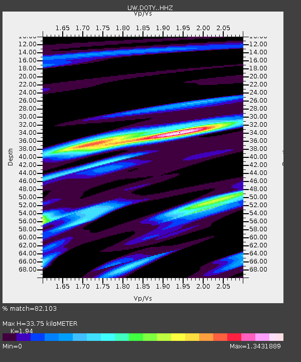
| Estimated Moho Depth: |
33.75 km |
| Estimated Crust Vp/Vs: |
1.94 |
| Assumed Crust Vp: |
6.566 km/s |
| Estimated Crust Vs: |
3.385 km/s |
| Estimated Crust Poisson's Ratio: |
0.32 |
|
| Radial Match: |
82.103 % |
| Radial Bump: |
400 |
| Transverse Match: |
43.244347 % |
| Transverse Bump: |
400 |
| SOD ConfigId: |
33437571 |
| Insert Time: |
2024-02-23 20:36:39.449 +0000 |
| GWidth: |
2.5 |
| Max Bumps: |
400 |
| Tol: |
0.001 |
|

Signal To Noise
| Channel | StoN | STA | LTA |
| UW:DOTY: :HHZ:20240209T20:13:18.579987Z | 3.968978 | 7.889051E-7 | 1.9876782E-7 |
| UW:DOTY: :HHN:20240209T20:13:18.579987Z | 3.2977977 | 5.7614443E-7 | 1.7470582E-7 |
| UW:DOTY: :HHE:20240209T20:13:18.579987Z | 3.1700575 | 6.1433417E-7 | 1.9379274E-7 |
| Arrivals |
| Ps | 5.2 SECOND |
| PpPs | 14 SECOND |
| PsPs/PpSs | 19 SECOND |


