You are here: Home > Network List > UW - Pacific Northwest Regional Seismic Network Stations List
> Station IRON Crane, OR, USA > Earthquake Result Viewer
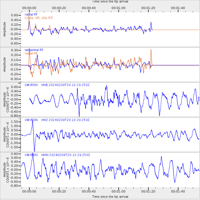
IRON Crane, OR, USA - Earthquake Result Viewer
*The percent match for this event was below the threshold and hence no stack was calculated.
| Earthquake location: |
Hawaii |
| Earthquake latitude/longitude: |
19.0/-155.5 |
| Earthquake time(UTC): |
2024/02/09 (040) 20:06:30 GMT |
| Earthquake Depth: |
10 km |
| Earthquake Magnitude: |
6.3 Mi |
| Earthquake Catalog/Contributor: |
NEIC PDE/pt |
|
| Network: |
UW Pacific Northwest Regional Seismic Network |
| Station: |
IRON Crane, OR, USA |
| Lat/Lon: |
43.36 N/118.47 W |
| Elevation: |
1226 m |
|
| Distance: |
39.4 deg |
| Az: |
43.799 deg |
| Baz: |
243.854 deg |
| Ray Param: |
$rayparam |
*The percent match for this event was below the threshold and hence was not used in the summary stack. |
|
| Radial Match: |
52.71678 % |
| Radial Bump: |
400 |
| Transverse Match: |
37.66801 % |
| Transverse Bump: |
288 |
| SOD ConfigId: |
33437571 |
| Insert Time: |
2024-02-23 20:37:12.897 +0000 |
| GWidth: |
2.5 |
| Max Bumps: |
400 |
| Tol: |
0.001 |
|
Signal To Noise
| Channel | StoN | STA | LTA |
| UW:IRON: :HHZ:20240209T20:13:29.250Z | 6.620599 | 8.5701294E-7 | 1.2944643E-7 |
| UW:IRON: :HHN:20240209T20:13:29.250Z | 2.7338808 | 4.090553E-7 | 1.4962441E-7 |
| UW:IRON: :HHE:20240209T20:13:29.250Z | 1.8034875 | 2.8647065E-7 | 1.5884261E-7 |
| Arrivals |
| Ps | |
| PpPs | |
| PsPs/PpSs | |


