You are here: Home > Network List > II - Global Seismograph Network (GSN - IRIS/IDA) Stations List
> Station TAU Hobart, Tasmania, Australia > Earthquake Result Viewer
TAU Hobart, Tasmania, Australia - Earthquake Result Viewer
| Earthquake location: |
Vanuatu Islands |
| Earthquake latitude/longitude: |
-13.9/167.2 |
| Earthquake time(UTC): |
2014/01/01 (001) 16:03:29 GMT |
| Earthquake Depth: |
187 km |
| Earthquake Magnitude: |
6.5 MWW, 6.5 MWC, 6.6 MWC, 6.6 MI, 6.6 MWB |
| Earthquake Catalog/Contributor: |
NEIC PDE/NEIC COMCAT |
|
| Network: |
II Global Seismograph Network (GSN - IRIS/IDA) |
| Station: |
TAU Hobart, Tasmania, Australia |
| Lat/Lon: |
42.91 S/147.32 E |
| Elevation: |
132 m |
|
| Distance: |
33.7 deg |
| Az: |
206.862 deg |
| Baz: |
36.677 deg |
| Ray Param: |
0.07748438 |
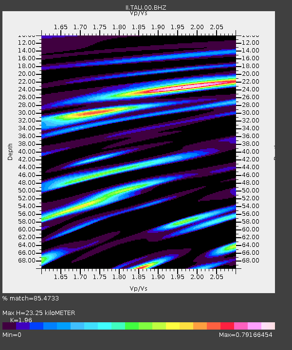
| Estimated Moho Depth: |
23.25 km |
| Estimated Crust Vp/Vs: |
1.96 |
| Assumed Crust Vp: |
6.477 km/s |
| Estimated Crust Vs: |
3.304 km/s |
| Estimated Crust Poisson's Ratio: |
0.32 |
|
| Radial Match: |
85.4733 % |
| Radial Bump: |
400 |
| Transverse Match: |
72.651245 % |
| Transverse Bump: |
400 |
| SOD ConfigId: |
3382691 |
| Insert Time: |
2019-04-09 20:24:37.708 +0000 |
| GWidth: |
2.5 |
| Max Bumps: |
400 |
| Tol: |
0.001 |
|

Signal To Noise
| Channel | StoN | STA | LTA |
| II:TAU:00:BHZ:20140101T16:09:21.618988Z | 15.541899 | 1.3442022E-5 | 8.648893E-7 |
| II:TAU:00:BH1:20140101T16:09:21.618988Z | 7.636629 | 5.4536813E-6 | 7.1414775E-7 |
| II:TAU:00:BH2:20140101T16:09:21.618988Z | 6.7560596 | 6.3047664E-6 | 9.332017E-7 |
| Arrivals |
| Ps | 3.7 SECOND |
| PpPs | 9.9 SECOND |
| PsPs/PpSs | 14 SECOND |


