You are here: Home > Network List > PS - Pacific21 Stations List
> Station PSI Parapat, Indonesia > Earthquake Result Viewer
PSI Parapat, Indonesia - Earthquake Result Viewer
| Earthquake location: |
Vanuatu Islands |
| Earthquake latitude/longitude: |
-13.9/167.2 |
| Earthquake time(UTC): |
2014/01/01 (001) 16:03:29 GMT |
| Earthquake Depth: |
187 km |
| Earthquake Magnitude: |
6.5 MWW, 6.5 MWC, 6.6 MWC, 6.6 MI, 6.6 MWB |
| Earthquake Catalog/Contributor: |
NEIC PDE/NEIC COMCAT |
|
| Network: |
PS Pacific21 |
| Station: |
PSI Parapat, Indonesia |
| Lat/Lon: |
2.69 N/98.92 E |
| Elevation: |
987 m |
|
| Distance: |
69.7 deg |
| Az: |
278.165 deg |
| Baz: |
105.752 deg |
| Ray Param: |
0.05496056 |
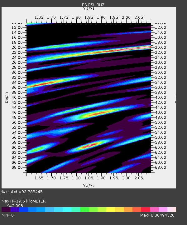
| Estimated Moho Depth: |
19.5 km |
| Estimated Crust Vp/Vs: |
2.10 |
| Assumed Crust Vp: |
6.468 km/s |
| Estimated Crust Vs: |
3.087 km/s |
| Estimated Crust Poisson's Ratio: |
0.35 |
|
| Radial Match: |
93.788445 % |
| Radial Bump: |
400 |
| Transverse Match: |
89.091835 % |
| Transverse Bump: |
400 |
| SOD ConfigId: |
3382691 |
| Insert Time: |
2019-04-09 20:25:06.320 +0000 |
| GWidth: |
2.5 |
| Max Bumps: |
400 |
| Tol: |
0.001 |
|
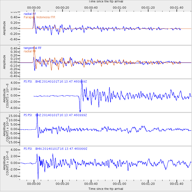
Signal To Noise
| Channel | StoN | STA | LTA |
| PS:PSI: :BHZ:20140101T16:13:47.460999Z | 88.22141 | 5.715132E-6 | 6.478169E-8 |
| PS:PSI: :BHN:20140101T16:13:47.460999Z | 8.493594 | 1.4750835E-6 | 1.7367012E-7 |
| PS:PSI: :BHE:20140101T16:13:47.460999Z | 26.359695 | 2.349775E-6 | 8.914272E-8 |
| Arrivals |
| Ps | 3.4 SECOND |
| PpPs | 9.0 SECOND |
| PsPs/PpSs | 12 SECOND |


