You are here: Home > Network List > XG92 - Rocky Mountain Front Stations List
> Station CRG Craig, CO > Earthquake Result Viewer
CRG Craig, CO - Earthquake Result Viewer
| Earthquake location: |
Svalbard Region |
| Earthquake latitude/longitude: |
78.5/5.1 |
| Earthquake time(UTC): |
1992/07/20 (202) 07:46:46 GMT |
| Earthquake Depth: |
10 km |
| Earthquake Magnitude: |
5.8 MB, 6.3 MS |
| Earthquake Catalog/Contributor: |
WHDF/NEIC |
|
| Network: |
XG Rocky Mountain Front |
| Station: |
CRG Craig, CO |
| Lat/Lon: |
40.54 N/107.41 W |
| Elevation: |
1974 m |
|
| Distance: |
54.9 deg |
| Az: |
300.542 deg |
| Baz: |
13.143 deg |
| Ray Param: |
0.06517969 |
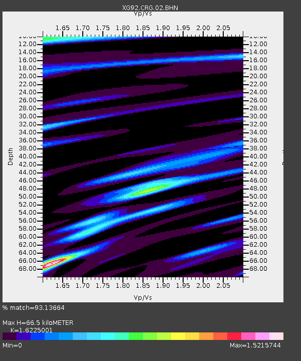
| Estimated Moho Depth: |
66.5 km |
| Estimated Crust Vp/Vs: |
1.62 |
| Assumed Crust Vp: |
6.159 km/s |
| Estimated Crust Vs: |
3.796 km/s |
| Estimated Crust Poisson's Ratio: |
0.19 |
|
| Radial Match: |
93.13664 % |
| Radial Bump: |
400 |
| Transverse Match: |
80.504486 % |
| Transverse Bump: |
400 |
| SOD ConfigId: |
3286 |
| Insert Time: |
2010-02-25 20:08:14.557 +0000 |
| GWidth: |
2.5 |
| Max Bumps: |
400 |
| Tol: |
0.001 |
|
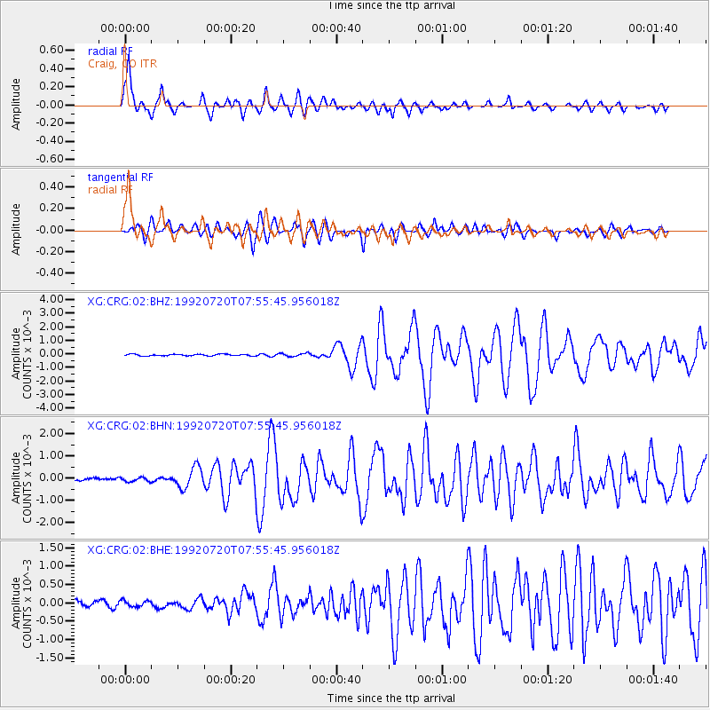
Signal To Noise
| Channel | StoN | STA | LTA |
| XG:CRG:02:BHN:19920720T07:55:45.956018Z | 1.2357382 | 9.337267E-5 | 7.556024E-5 |
| XG:CRG:02:BHE:19920720T07:55:45.956018Z | 1.3250656 | 1.0109065E-4 | 7.629105E-5 |
| XG:CRG:02:BHZ:19920720T07:55:45.956018Z | 1.9854214 | 1.18532065E-4 | 5.970121E-5 |
| Arrivals |
| Ps | 7.1 SECOND |
| PpPs | 27 SECOND |
| PsPs/PpSs | 34 SECOND |


