You are here: Home > Network List > TA - USArray Transportable Network (new EarthScope stations) Stations List
> Station Y32A R-V Farms, Vernon, TX, USA > Earthquake Result Viewer
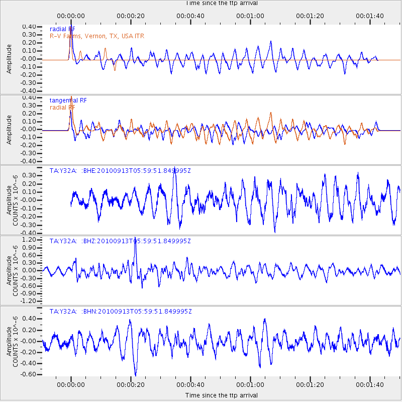
Y32A R-V Farms, Vernon, TX, USA - Earthquake Result Viewer
*The percent match for this event was below the threshold and hence no stack was calculated.
| Earthquake location: |
Hokkaido, Japan Region |
| Earthquake latitude/longitude: |
41.5/142.0 |
| Earthquake time(UTC): |
2010/09/13 (256) 05:47:48 GMT |
| Earthquake Depth: |
61 km |
| Earthquake Magnitude: |
5.8 MB, 5.8 MW, 5.8 MW |
| Earthquake Catalog/Contributor: |
WHDF/NEIC |
|
| Network: |
TA USArray Transportable Network (new EarthScope stations) |
| Station: |
Y32A R-V Farms, Vernon, TX, USA |
| Lat/Lon: |
34.00 N/99.44 W |
| Elevation: |
412 m |
|
| Distance: |
86.0 deg |
| Az: |
46.995 deg |
| Baz: |
318.599 deg |
| Ray Param: |
$rayparam |
*The percent match for this event was below the threshold and hence was not used in the summary stack. |
|
| Radial Match: |
57.968124 % |
| Radial Bump: |
400 |
| Transverse Match: |
50.572647 % |
| Transverse Bump: |
363 |
| SOD ConfigId: |
319893 |
| Insert Time: |
2011-01-20 07:58:32.032 +0000 |
| GWidth: |
2.5 |
| Max Bumps: |
400 |
| Tol: |
0.001 |
|
Signal To Noise
| Channel | StoN | STA | LTA |
| TA:Y32A: :BHZ:20100913T05:59:51.849995Z | 2.0512521 | 2.1838363E-7 | 1.0646358E-7 |
| TA:Y32A: :BHN:20100913T05:59:51.849995Z | 1.1273574 | 1.2054862E-7 | 1.0693025E-7 |
| TA:Y32A: :BHE:20100913T05:59:51.849995Z | 2.3470745 | 1.8748398E-7 | 7.9879854E-8 |
| Arrivals |
| Ps | |
| PpPs | |
| PsPs/PpSs | |


