You are here: Home > Network List > TA - USArray Transportable Network (new EarthScope stations) Stations List
> Station S28A Manter, KS, USA > Earthquake Result Viewer
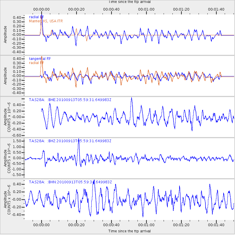
S28A Manter, KS, USA - Earthquake Result Viewer
*The percent match for this event was below the threshold and hence no stack was calculated.
| Earthquake location: |
Hokkaido, Japan Region |
| Earthquake latitude/longitude: |
41.5/142.0 |
| Earthquake time(UTC): |
2010/09/13 (256) 05:47:48 GMT |
| Earthquake Depth: |
61 km |
| Earthquake Magnitude: |
5.8 MB, 5.8 MW, 5.8 MW |
| Earthquake Catalog/Contributor: |
WHDF/NEIC |
|
| Network: |
TA USArray Transportable Network (new EarthScope stations) |
| Station: |
S28A Manter, KS, USA |
| Lat/Lon: |
37.59 N/101.90 W |
| Elevation: |
1064 m |
|
| Distance: |
82.1 deg |
| Az: |
46.069 deg |
| Baz: |
317.072 deg |
| Ray Param: |
$rayparam |
*The percent match for this event was below the threshold and hence was not used in the summary stack. |
|
| Radial Match: |
66.61574 % |
| Radial Bump: |
400 |
| Transverse Match: |
57.900513 % |
| Transverse Bump: |
400 |
| SOD ConfigId: |
319893 |
| Insert Time: |
2011-01-20 08:00:08.402 +0000 |
| GWidth: |
2.5 |
| Max Bumps: |
400 |
| Tol: |
0.001 |
|
Signal To Noise
| Channel | StoN | STA | LTA |
| TA:S28A: :BHZ:20100913T05:59:31.649983Z | 3.7544909 | 3.6055476E-7 | 9.603293E-8 |
| TA:S28A: :BHN:20100913T05:59:31.649983Z | 1.0483356 | 1.18678834E-7 | 1.1320691E-7 |
| TA:S28A: :BHE:20100913T05:59:31.649983Z | 0.70939004 | 1.2496137E-7 | 1.7615328E-7 |
| Arrivals |
| Ps | |
| PpPs | |
| PsPs/PpSs | |


