You are here: Home > Network List > TA - USArray Transportable Network (new EarthScope stations) Stations List
> Station R29A Marienthal, KS, USA > Earthquake Result Viewer
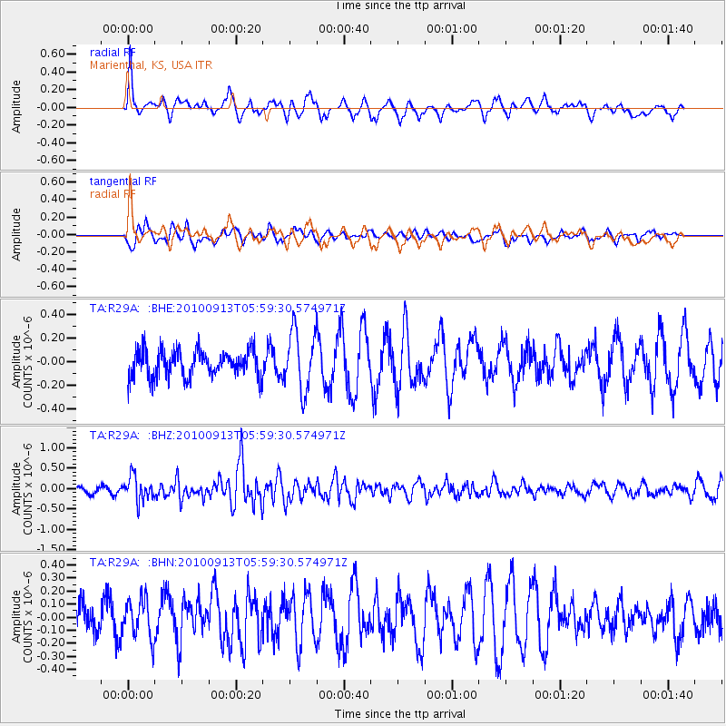
R29A Marienthal, KS, USA - Earthquake Result Viewer
*The percent match for this event was below the threshold and hence no stack was calculated.
| Earthquake location: |
Hokkaido, Japan Region |
| Earthquake latitude/longitude: |
41.5/142.0 |
| Earthquake time(UTC): |
2010/09/13 (256) 05:47:48 GMT |
| Earthquake Depth: |
61 km |
| Earthquake Magnitude: |
5.8 MB, 5.8 MW, 5.8 MW |
| Earthquake Catalog/Contributor: |
WHDF/NEIC |
|
| Network: |
TA USArray Transportable Network (new EarthScope stations) |
| Station: |
R29A Marienthal, KS, USA |
| Lat/Lon: |
38.42 N/101.14 W |
| Elevation: |
957 m |
|
| Distance: |
81.9 deg |
| Az: |
45.053 deg |
| Baz: |
317.395 deg |
| Ray Param: |
$rayparam |
*The percent match for this event was below the threshold and hence was not used in the summary stack. |
|
| Radial Match: |
69.61048 % |
| Radial Bump: |
400 |
| Transverse Match: |
63.828712 % |
| Transverse Bump: |
400 |
| SOD ConfigId: |
319893 |
| Insert Time: |
2011-01-20 08:00:46.910 +0000 |
| GWidth: |
2.5 |
| Max Bumps: |
400 |
| Tol: |
0.001 |
|
Signal To Noise
| Channel | StoN | STA | LTA |
| TA:R29A: :BHZ:20100913T05:59:30.574971Z | 3.4412355 | 2.9960276E-7 | 8.706256E-8 |
| TA:R29A: :BHN:20100913T05:59:30.574971Z | 1.3901354 | 1.5170531E-7 | 1.0912987E-7 |
| TA:R29A: :BHE:20100913T05:59:30.574971Z | 2.3004858 | 2.5742773E-7 | 1.11901464E-7 |
| Arrivals |
| Ps | |
| PpPs | |
| PsPs/PpSs | |


