You are here: Home > Network List > AV - Alaska Volcano Observatory Stations List
> Station PLBL Mt. Peulik Volcano, Alaska > Earthquake Result Viewer
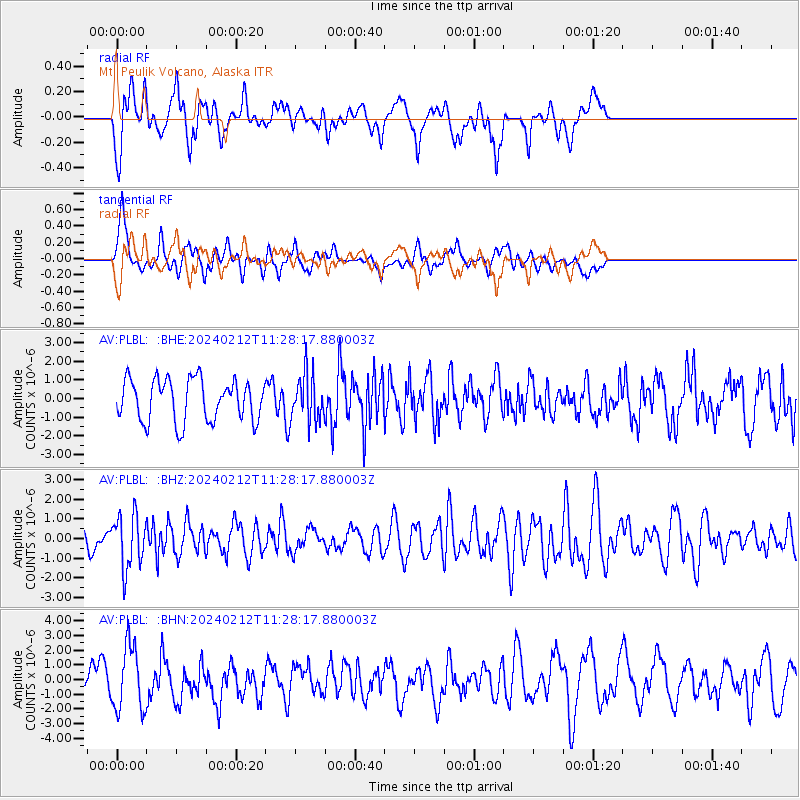
PLBL Mt. Peulik Volcano, Alaska - Earthquake Result Viewer
*The percent match for this event was below the threshold and hence no stack was calculated.
| Earthquake location: |
Volcano Islands, Japan Region |
| Earthquake latitude/longitude: |
22.0/142.7 |
| Earthquake time(UTC): |
2024/02/12 (043) 11:19:36 GMT |
| Earthquake Depth: |
250 km |
| Earthquake Magnitude: |
6.1 mww |
| Earthquake Catalog/Contributor: |
NEIC PDE/us |
|
| Network: |
AV Alaska Volcano Observatory |
| Station: |
PLBL Mt. Peulik Volcano, Alaska |
| Lat/Lon: |
57.70 N/156.82 W |
| Elevation: |
461 m |
|
| Distance: |
55.9 deg |
| Az: |
34.326 deg |
| Baz: |
257.022 deg |
| Ray Param: |
$rayparam |
*The percent match for this event was below the threshold and hence was not used in the summary stack. |
|
| Radial Match: |
66.14921 % |
| Radial Bump: |
400 |
| Transverse Match: |
55.484795 % |
| Transverse Bump: |
400 |
| SOD ConfigId: |
33437571 |
| Insert Time: |
2024-02-26 11:29:06.638 +0000 |
| GWidth: |
2.5 |
| Max Bumps: |
400 |
| Tol: |
0.001 |
|
Signal To Noise
| Channel | StoN | STA | LTA |
| AV:PLBL: :BHZ:20240212T11:28:17.880003Z | 3.2728987 | 1.3673673E-6 | 4.1778478E-7 |
| AV:PLBL: :BHN:20240212T11:28:17.880003Z | 2.0665636 | 2.202124E-6 | 1.0655971E-6 |
| AV:PLBL: :BHE:20240212T11:28:17.880003Z | 1.1390127 | 1.2744588E-6 | 1.1189153E-6 |
| Arrivals |
| Ps | |
| PpPs | |
| PsPs/PpSs | |


