You are here: Home > Network List > TA - USArray Transportable Network (new EarthScope stations) Stations List
> Station W36A Wetumka, OK, USA > Earthquake Result Viewer
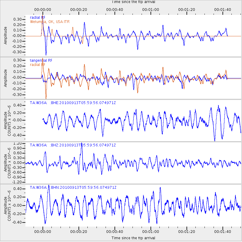
W36A Wetumka, OK, USA - Earthquake Result Viewer
*The percent match for this event was below the threshold and hence no stack was calculated.
| Earthquake location: |
Hokkaido, Japan Region |
| Earthquake latitude/longitude: |
41.5/142.0 |
| Earthquake time(UTC): |
2010/09/13 (256) 05:47:48 GMT |
| Earthquake Depth: |
61 km |
| Earthquake Magnitude: |
5.8 MB, 5.8 MW, 5.8 MW |
| Earthquake Catalog/Contributor: |
WHDF/NEIC |
|
| Network: |
TA USArray Transportable Network (new EarthScope stations) |
| Station: |
W36A Wetumka, OK, USA |
| Lat/Lon: |
35.14 N/96.23 W |
| Elevation: |
251 m |
|
| Distance: |
86.9 deg |
| Az: |
44.238 deg |
| Baz: |
320.246 deg |
| Ray Param: |
$rayparam |
*The percent match for this event was below the threshold and hence was not used in the summary stack. |
|
| Radial Match: |
74.92444 % |
| Radial Bump: |
333 |
| Transverse Match: |
54.290916 % |
| Transverse Bump: |
400 |
| SOD ConfigId: |
319893 |
| Insert Time: |
2011-01-20 08:13:25.315 +0000 |
| GWidth: |
2.5 |
| Max Bumps: |
400 |
| Tol: |
0.001 |
|
Signal To Noise
| Channel | StoN | STA | LTA |
| TA:W36A: :BHZ:20100913T05:59:56.074971Z | 5.168661 | 3.4487107E-7 | 6.672348E-8 |
| TA:W36A: :BHN:20100913T05:59:56.074971Z | 2.1539733 | 2.6624446E-7 | 1.236062E-7 |
| TA:W36A: :BHE:20100913T05:59:56.074971Z | 1.7212619 | 2.0935128E-7 | 1.2162663E-7 |
| Arrivals |
| Ps | |
| PpPs | |
| PsPs/PpSs | |


