You are here: Home > Network List > TA - USArray Transportable Network (new EarthScope stations) Stations List
> Station Y37A Hugo, OK, USA > Earthquake Result Viewer
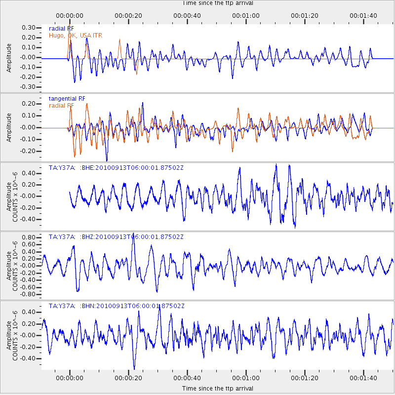
Y37A Hugo, OK, USA - Earthquake Result Viewer
*The percent match for this event was below the threshold and hence no stack was calculated.
| Earthquake location: |
Hokkaido, Japan Region |
| Earthquake latitude/longitude: |
41.5/142.0 |
| Earthquake time(UTC): |
2010/09/13 (256) 05:47:48 GMT |
| Earthquake Depth: |
61 km |
| Earthquake Magnitude: |
5.8 MB, 5.8 MW, 5.8 MW |
| Earthquake Catalog/Contributor: |
WHDF/NEIC |
|
| Network: |
TA USArray Transportable Network (new EarthScope stations) |
| Station: |
Y37A Hugo, OK, USA |
| Lat/Lon: |
33.98 N/95.62 W |
| Elevation: |
165 m |
|
| Distance: |
88.1 deg |
| Az: |
44.591 deg |
| Baz: |
320.603 deg |
| Ray Param: |
$rayparam |
*The percent match for this event was below the threshold and hence was not used in the summary stack. |
|
| Radial Match: |
45.090797 % |
| Radial Bump: |
400 |
| Transverse Match: |
61.794353 % |
| Transverse Bump: |
400 |
| SOD ConfigId: |
319893 |
| Insert Time: |
2011-01-20 08:14:41.928 +0000 |
| GWidth: |
2.5 |
| Max Bumps: |
400 |
| Tol: |
0.001 |
|
Signal To Noise
| Channel | StoN | STA | LTA |
| TA:Y37A: :BHZ:20100913T06:00:01.87502Z | 2.9945033 | 3.8437872E-7 | 1.2836142E-7 |
| TA:Y37A: :BHN:20100913T06:00:01.87502Z | 0.73538405 | 1.2380795E-7 | 1.6835823E-7 |
| TA:Y37A: :BHE:20100913T06:00:01.87502Z | 1.0425855 | 1.3373754E-7 | 1.2827489E-7 |
| Arrivals |
| Ps | |
| PpPs | |
| PsPs/PpSs | |


