You are here: Home > Network List > CN - Canadian National Seismograph Network Stations List
> Station LLLB Lillooet, BC, CA > Earthquake Result Viewer
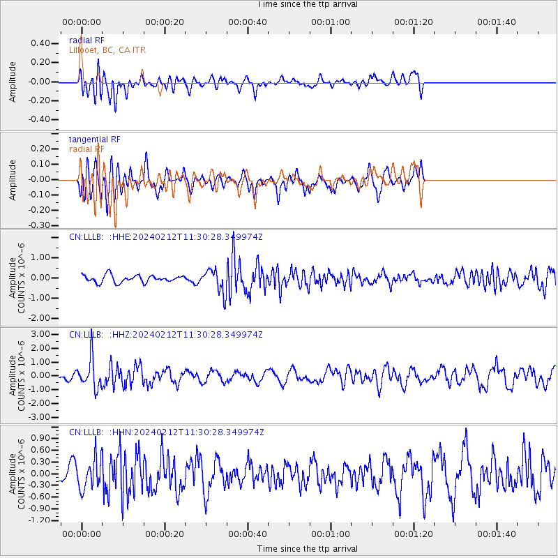
LLLB Lillooet, BC, CA - Earthquake Result Viewer
*The percent match for this event was below the threshold and hence no stack was calculated.
| Earthquake location: |
Volcano Islands, Japan Region |
| Earthquake latitude/longitude: |
22.0/142.7 |
| Earthquake time(UTC): |
2024/02/12 (043) 11:19:36 GMT |
| Earthquake Depth: |
250 km |
| Earthquake Magnitude: |
6.1 mww |
| Earthquake Catalog/Contributor: |
NEIC PDE/us |
|
| Network: |
CN Canadian National Seismograph Network |
| Station: |
LLLB Lillooet, BC, CA |
| Lat/Lon: |
50.61 N/121.88 W |
| Elevation: |
700 m |
|
| Distance: |
76.6 deg |
| Az: |
40.705 deg |
| Baz: |
288.248 deg |
| Ray Param: |
$rayparam |
*The percent match for this event was below the threshold and hence was not used in the summary stack. |
|
| Radial Match: |
44.923355 % |
| Radial Bump: |
400 |
| Transverse Match: |
67.243515 % |
| Transverse Bump: |
400 |
| SOD ConfigId: |
33437571 |
| Insert Time: |
2024-02-26 11:34:35.889 +0000 |
| GWidth: |
2.5 |
| Max Bumps: |
400 |
| Tol: |
0.001 |
|
Signal To Noise
| Channel | StoN | STA | LTA |
| CN:LLLB: :HHZ:20240212T11:30:28.349974Z | 2.784454 | 1.0990609E-6 | 3.9471328E-7 |
| CN:LLLB: :HHN:20240212T11:30:28.349974Z | 1.1848929 | 3.8136238E-7 | 3.218539E-7 |
| CN:LLLB: :HHE:20240212T11:30:28.349974Z | 3.3494987 | 5.9886344E-7 | 1.7879195E-7 |
| Arrivals |
| Ps | |
| PpPs | |
| PsPs/PpSs | |


