You are here: Home > Network List > GO - National Seismic Network of Georgia Stations List
> Station KHRT Khreiti, Georgia > Earthquake Result Viewer
KHRT Khreiti, Georgia - Earthquake Result Viewer
| Earthquake location: |
Volcano Islands, Japan Region |
| Earthquake latitude/longitude: |
22.0/142.7 |
| Earthquake time(UTC): |
2024/02/12 (043) 11:19:36 GMT |
| Earthquake Depth: |
250 km |
| Earthquake Magnitude: |
6.1 mww |
| Earthquake Catalog/Contributor: |
NEIC PDE/us |
|
| Network: |
GO National Seismic Network of Georgia |
| Station: |
KHRT Khreiti, Georgia |
| Lat/Lon: |
42.35 N/43.22 E |
| Elevation: |
1164 m |
|
| Distance: |
82.2 deg |
| Az: |
312.442 deg |
| Baz: |
67.474 deg |
| Ray Param: |
0.04646077 |
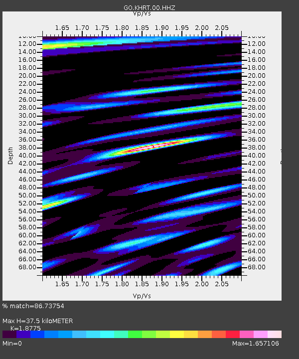
| Estimated Moho Depth: |
37.5 km |
| Estimated Crust Vp/Vs: |
1.88 |
| Assumed Crust Vp: |
6.247 km/s |
| Estimated Crust Vs: |
3.327 km/s |
| Estimated Crust Poisson's Ratio: |
0.30 |
|
| Radial Match: |
86.73754 % |
| Radial Bump: |
400 |
| Transverse Match: |
83.31794 % |
| Transverse Bump: |
400 |
| SOD ConfigId: |
33437571 |
| Insert Time: |
2024-02-26 11:36:11.839 +0000 |
| GWidth: |
2.5 |
| Max Bumps: |
400 |
| Tol: |
0.001 |
|

Signal To Noise
| Channel | StoN | STA | LTA |
| GO:KHRT:00:HHZ:20240212T11:30:58.239989Z | 38.84637 | 3.769448E-6 | 9.703476E-8 |
| GO:KHRT:00:HHN:20240212T11:30:58.239989Z | 8.674331 | 6.6409115E-7 | 7.65582E-8 |
| GO:KHRT:00:HHE:20240212T11:30:58.239989Z | 7.743222 | 1.0543949E-6 | 1.3617004E-7 |
| Arrivals |
| Ps | 5.4 SECOND |
| PpPs | 17 SECOND |
| PsPs/PpSs | 22 SECOND |


