You are here: Home > Network List > IU - Global Seismograph Network (GSN - IRIS/USGS) Stations List
> Station RSSD Black Hills, South Dakota, USA > Earthquake Result Viewer
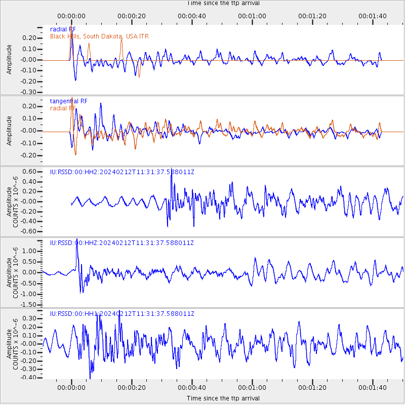
RSSD Black Hills, South Dakota, USA - Earthquake Result Viewer
*The percent match for this event was below the threshold and hence no stack was calculated.
| Earthquake location: |
Volcano Islands, Japan Region |
| Earthquake latitude/longitude: |
22.0/142.7 |
| Earthquake time(UTC): |
2024/02/12 (043) 11:19:36 GMT |
| Earthquake Depth: |
250 km |
| Earthquake Magnitude: |
6.1 mww |
| Earthquake Catalog/Contributor: |
NEIC PDE/us |
|
| Network: |
IU Global Seismograph Network (GSN - IRIS/USGS) |
| Station: |
RSSD Black Hills, South Dakota, USA |
| Lat/Lon: |
44.12 N/104.04 W |
| Elevation: |
2090 m |
|
| Distance: |
90.3 deg |
| Az: |
41.443 deg |
| Baz: |
301.492 deg |
| Ray Param: |
$rayparam |
*The percent match for this event was below the threshold and hence was not used in the summary stack. |
|
| Radial Match: |
56.138695 % |
| Radial Bump: |
400 |
| Transverse Match: |
52.31321 % |
| Transverse Bump: |
398 |
| SOD ConfigId: |
33437571 |
| Insert Time: |
2024-02-26 11:37:59.742 +0000 |
| GWidth: |
2.5 |
| Max Bumps: |
400 |
| Tol: |
0.001 |
|
Signal To Noise
| Channel | StoN | STA | LTA |
| IU:RSSD:00:HHZ:20240212T11:31:37.588011Z | 4.5908294 | 5.3564736E-7 | 1.1667769E-7 |
| IU:RSSD:00:HH1:20240212T11:31:37.588011Z | 1.568926 | 1.3156613E-7 | 8.385745E-8 |
| IU:RSSD:00:HH2:20240212T11:31:37.588011Z | 4.0576687 | 2.2370274E-7 | 5.5130855E-8 |
| Arrivals |
| Ps | |
| PpPs | |
| PsPs/PpSs | |


